
Grade 9 Social Science (Geography) — Chapter 2: Shaping of the Earth’s Surface
1. Structure of the Earth’s Interior & Plate Tectonics
- Landform (Core Definition): “A landform is a natural feature on the Earth’s surface formed by processes, such as weathering, erosion, deposition, and the movement of the Earth’s crust.” Examples include mountains, plateaus, plains, valleys, deserts, and coastal features.
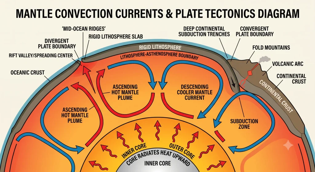
- Three Concentric Layers of the Earth:
- Crust: Outermost rigid layer जिस पर हम रहते हैं। इसकी thickness continents के नीचे 30–40 km और ocean floors के नीचे 5–7 km होती है।
- Mantle: Thick solid/semi-solid layer जो crust और outer core के बीच स्थित है (लगभग 2900 km गहरी)।
- Core: Innermost heavy layer जो दो भागों में विभाजित है:
- Outer Core: A fluid layer (2200 km) जो मुख्य रूप से iron and nickel से बनी है।
- Inner Core: A solid, hot spinning metal ball (1250 km) जो Earth का densest part है।
- Lithosphere and Asthenosphere:
- Lithosphere (100 km): The rigid outer layer of the Earth composed of the entire crust and the upper mantle। यह continuous नहीं है, बल्कि fragmented slabs में टूटी हुई है जिन्हें Tectonic Plates कहते हैं।
- Asthenosphere (200 km): Lithosphere के ठीक नीचे स्थित a hot, mobile layer of partially molten rock। यह semi-molten consistency plates को इसके ऊपर smoothly glide करने की सुविधा देती है।
- Theory of Plate Tectonics:
- Propounded By: इस क्रांतिकारी सिद्धांत को W.J. Morgan ने formulate किया था।
- Core Concept: Earth का outer shell massive slabs of solid rock में टूटा हुआ है जो प्रति वर्ष कुछ centimeters की दर से अत्यंत धीमी गति से move करती हैं।
- Types of Tectonic Plates:
- Continental Plates: जो continents (महाद्वीपों) को carry करती हैं।
- Oceanic Plates: जो ocean basins (महासागरीय नितल) को carry करती हैं।
- Mixed Plates: जो continents और oceans दोनों को carry करती हैं।
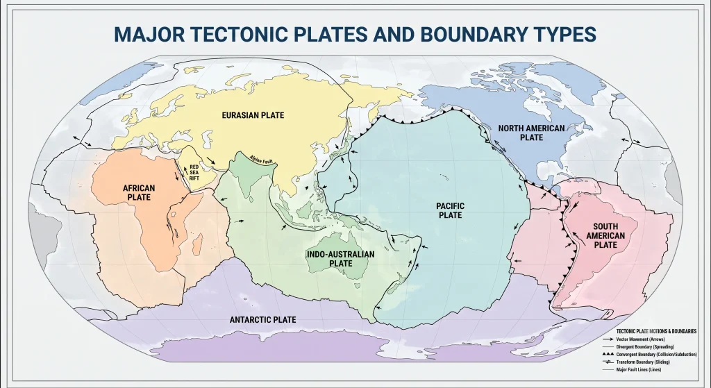
- Major Tectonic Plates of the World: Pacific Plate, Eurasian Plate, African Plate, North American Plate, South American Plate, Indo-Australian Plate, and Antarctic Plate।
2. Mechanism of Plate Movement & Types of Plate Boundaries
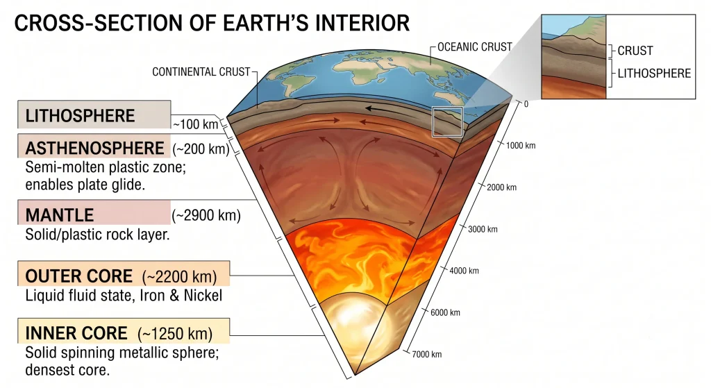
- Driving Engine: Convection Currents in the Mantle:
- Earth के core से निकलने वाली प्रचंड heat mantle के निचले भाग के molten rock material को गर्म करती है।
- Hot molten material ऊपर की ओर rise करता है और ठंडा material नीचे sink करता है।
- इस circular heat engine से Convection currents पैदा होते हैं, जो floating tectonic plates को अलग-अलग दिशाओं में push और pull करते हैं।
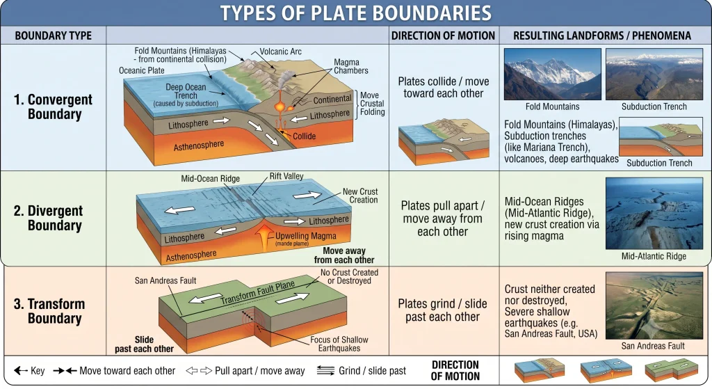
- Plate Boundaries (प्लेट सीमाएँ): जहाँ दो tectonic plates आपस में मिलती हैं, उन्हें Plate Boundaries कहा जाता है। ये मुख्य रूप से तीन प्रकार की होती हैं:
- Detailed Boundary Dynamics:
- Convergent Boundary: जब दो continental plates टकराती हैं, तो crust fold होकर Fold Mountains बनाती है (उदा. Indian plate और Eurasian plate की टक्कर से बने Himalayas)। जब oceanic plate किसी continental plate से टकराती है, तो heavier oceanic plate mantle में नीचे धँस जाती है (subduction zone), जिससे volcanic eruptions और severe earthquakes आते हैं[cite: 137]।
- Divergent Boundary: Plates एक-दूसरे से दूर खिंचती हैं, जिससे बना gap नीचे से rise होने वाले magma से भरता है और new oceanic crust बनती है (उदा. Mid-Atlantic Ridge)[cite: 137]।
- Transform Boundary: Plates बिना किसी crustal creation या destruction के laterally एक-दूसरे से रगड़ खाते हुए slide करती हैं (उदा. USA की San Andreas Fault)[cite: 137]।
- The Pacific “Ring of Fire”:
- Pacific Ocean के चारों ओर फैला horse-shoe shaped belt जहाँ world के अधिकांश active volcanoes और destructive earthquakes केंद्रित हैं।
- Indigenous Observation & Historical Perspectives (Varāhamihira):
- प्राचीन भारत में earthquakes को ‘bhūkampa’ कहा जाता था।
- महान खगोलशास्त्री Varāhamihira ने अपनी कृति Brihatsamhitā में earthquakes के संकेतों (बादलों में परिवर्तन, पशुओं का असामान्य व्यवहार, वायु-परिवर्तन) को चार प्राकृतिक तत्वों—Vāyu (वायु), Agni (अग्नि), Indra (आकाश/गर्जन), और Varuṇa (जल)—से जोड़कर विश्लेषित किया था।
- Baratang Mud Volcano (Andaman & Nicobar Islands):
- भारत का एकमात्र Mud Volcano, जहाँ fiery lava के बजाय underground natural gases और high pressure के कारण ठंडी कीचड़ (mud) सतह पर bubble out होती है।
3. Exogenic Forces: Weathering, Erosion, and Traditional Conservation
Earth की surface दो प्रकार की forces द्वारा निरंतर reshape होती है: Endogenic (आंतरिक बल) जो relief features को उभारते हैं, और Exogenic (बहिर्जनिक बल) जो उन्हें तराशते और समतल करते हैं।
- Weathering (Core Definition): “Weathering is the process through which rocks on the Earth’s surface break down into smaller pieces due to various processes. It does not involve movement of the broken material, only the breaking down.” (यह rocks का अपनी ही जगह पर static disintegration है)।
- Three Types of Weathering:
- Physical / Mechanical Weathering: Temperature fluctuations (दिन में तेज धूप से फैलना और रात में सिकुड़ना), frost wedging (दरारों में बर्फ जमने से फैलाव), और wind action से चट्टानों का टूटना।
- Chemical Weathering: Rainwater, atmospheric gases (oxygen, carbon dioxide) या acids के साथ minerals का chemical reaction होना जिससे rocks disintegrate हो जाती हैं।
- Biological Weathering: Plants की जड़ों का चट्टानों की दरारों में घुसकर उन्हें फाड़ देना, burrowing animals, और micro-organisms द्वारा decomposition।
- Erosion (Core Definition): “Erosion is the process by which soil, rocks, and other surface materials are worn away and carried from one place to another by natural agents like water, wind, ice, or waves.” (इसमें broken material का active dynamic transportation शामिल होता है)।
- Impact of Erosion on Human Livelihoods:
- Farmers की fertile topsoil बह जाने से crop yields घट जाती हैं।
- Coastal और riverine erosion बस्तियों, सड़कों और मकानों को बहा ले जाता है।
- Mining और construction sites unstable होकर safety hazards पैदा करती हैं।
- Traditional Indian Soil & Water Conservation Techniques:
- Contouring: Hillside slopes पर contour lines के समानांतर Continuous Contour Trenches (CCT) खोदना ताकि runoff धीमा हो और groundwater recharge हो।
- Bunding: Contour lines के साथ मिट्टी की मेड़ें (earthen embankments) बनाना जो soil moisture को retain रखती हैं और erosion रोकती हैं।
- Terracing: ढलानों पर सीढ़ीनुमा सपाट खेत तैयार करना।
- The Zabo System (Nagaland): नगालैंड की एक प्राचीन indigenous integrated farming technique जहाँ पहाड़ी ढलानों पर earthen bunds और forest cover का उपयोग करके soil और runoff water को संरक्षित किया जाता है।
4. Agents of Gradation & Resulting Landforms
- Agents of Gradation (Core Definition): “Agents of gradation are natural forces that wear down, transport, and deposit materials on the Earth’s surface, helping to level or smooth it over time.” High relief को काटना degradation कहलाता है और low basins को भरना aggradation कहलाता है।
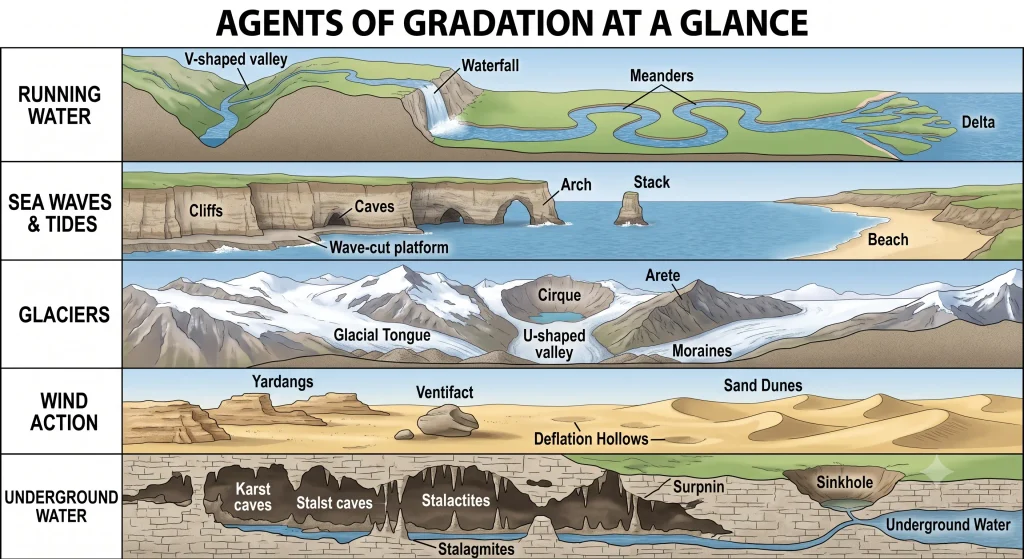
I. Running Water (नदियाँ और प्रवाहित जल)
- Upper Course (Youth Stage): Steep gradient और high energy के कारण vertical downcutting होती है। Resulting features: V-shaped valleys, Rapids, and Waterfalls।
- Waterfall: जब नदी hard rock layer से softer rock layer पर गिरती है, तो नीचे की soft rock तेजी से erode हो जाती है, जिससे vertical cliff और नीचे Plunge Pool का निर्माण होता है। (Used for hydroelectricity and tourism)।
- Middle Course (Mature Stage): Gradient कम होने से नदी lateral erosion शुरू करती है।
- Meander: नदी के प्रवाह में बनने वाले बड़े घुमावदार मोड़। Outer bank पर active erosion (steep cut-bank) और inner bank पर continuous deposition (slip-off slope / sand bar) से loops बनते हैं।
- Oxbow Lake: जब meander loop अत्यधिक संकरा होकर मुख्य नदी से कट जाता है, तो अर्धचंद्राकार झील बनती है।
- Historical Irrigation: तमिलनाडु में कावेरी नदी पर 2nd century CE में निर्मित Grand Anicut (Kallanai) नदी जल के बुद्धिमत्तापूर्ण प्रबंधन का प्राचीन उदाहरण है।
- Lower Course (Old Stage): नदी की गति अत्यंत धीमी हो जाती है और वह भारी मात्रा में sediment deposit करती है।
- Delta: नदी के मुहाने (mouth) पर बनने वाला fan-shaped या triangular alluvial deposit जहाँ नदी multiple Distributaries में बंट जाती है।
- Sundarbans Delta: गंगा-ब्रह्मपुत्र द्वारा निर्मित world का largest delta, जो अपनी fertile alluvial soil, mangrove forests, और rich biodiversity के लिए प्रसिद्ध है।
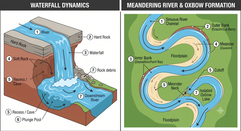
II. Waves and Currents (तटीय प्रक्रियाएँ)
- Coastal Erosional Landforms:
- Sea Cliff: समुद्र के किनारे खड़ी चट्टानी दीवार जो तरंगों द्वारा base पर निरंतर कटाव (undercutting) से बनती है।
- Wave-Cut Platform (Shore Platform): Cliff के पीछे हटने के बाद बेस पर छूटी हुई सपाट चट्टानी सतह।
- Sea Cave: चट्टान के कमजोर fracture zones में तरंगों के प्रहार से बनने वाली खोखली गुफा।
- Sea Arch: जब किसी headland के दोनों छोरों की caves कटकर आपस में मिल जाती हैं, तो प्राकृतिक मेहराब बनता है।
- Sea Stack: Arch की roof के collapse हो जाने के बाद समुद्र में खड़ा रह जाने वाला isolated rocky pillar।
- Coastal Depositional Landforms:
- Beach: तरंगों और धाराओं द्वारा किनारे पर रेत, कंकड़ और पत्थरों (pebbles) के निक्षेपण से बना तट। Beaches coastal erosion के विरुद्ध natural protective buffer की तरह कार्य करते हैं।
III. Glaciers (हिमनद)
- Glacial Erosional Landforms:
- U-shaped Valley (Glacial Trough): जब glacier किसी पुरानी V-shaped valley से गुजरता है, तो वह उसके तल को गहरा और किनारों को चौड़ा करके सपाट तली वाली खड़ी ढाल वाली U-आकार की घाटी बनाता है।
- Cirque: हिमनद के शीर्ष (head) पर बनने वाला arm-chair shaped या bowl-shaped गहरा गर्त।
- Arête: दो adjacent cirques या glacial valleys के बीच की धारदार, आरीनुमा नुकीली कटक (sharp ridge)।
- Hanging Valley: मुख्य बड़ी हिमनदी की घाटी में ऊपर लटकती हुई सहायक हिमनदी की उथली घाटी, जिस पर प्रायः झरने बनते हैं।
- Fjords: समुद्र तट पर स्थित गहरी, जलमग्न हिमनद घाटियाँ जो उत्कृष्ट natural harbours प्रदान करती हैं।
- Glacial Depositional Landforms:
- Moraines: पिघलते हुए glacier द्वारा छोड़े गए unsorted rock debris और soil (जिसे Till कहते हैं) के जमाव।
- Lateral Moraines: हिमनद के दोनों पार्श्वों (किनारों) पर जमा मलबा।
- Medial Moraines: जब दो glaciers आपस में मिलते हैं, तो उनके lateral moraines मध्य में मिलकर एकल कटक बनाते हैं।
- Terminal Moraine: हिमनद के snout (अंतिम छोर) पर जमा debris जो उसके अधिकतम विस्तार को दर्शाता है।
- Moraines: पिघलते हुए glacier द्वारा छोड़े गए unsorted rock debris और soil (जिसे Till कहते हैं) के जमाव।
IV. Wind Action (पवन के कार्य – Arid Landscapes)
- Wind Erosional Landforms:
- Yardangs: पवन की दिशा के समानांतर hard और soft rocks के bands में soft rock के तेजी से कटने से बनी streamlined नुकीली चट्टानी दीवारें।
- Ventifacts: रेत के निरंतर घर्षण (sandblasting) से घिसी और तराशी गई चिकनी चट्टानें।
- Deflation Hollows (Blowouts): हवा द्वारा ढीली बालू उड़ा ले जाने से बने उथले गड्ढे; जब ये गड्ढे water table तक गहरे हो जाते हैं, तो वहाँ Oasis (मरूद्यान) बनता है।
- Wind Depositional Landforms (Sand Dunes):
- Barchans: अर्धचंद्राकार (crescent-shaped) रेत के टीले, जिनके दो सींग (horns) पवन की दिशा में आगे निकले होते हैं; ये single wind direction वाले dry areas में बनते हैं।
- Transverse Dunes: पवन की दिशा के समकोण (perpendicular) पर बनने वाली रेत की तरंगित शृंखलाएं।
- Longitudinal Dunes: पवन की दिशा के समानांतर बनने वाली लंबी रेत की लकीरें।
- Star Dunes: बहु-भुजाओं वाले तारे के आकार के विशाल टीले, जो वहाँ बनते हैं जहाँ हवाएँ कई दिशाओं से चलती हैं।
V. Underground Water (Karst Topography)
- Mechanics: चूना पत्थर (Limestone / Calcium Carbonate) वाले क्षेत्रों में जब acidic rainwater दरारों में रिसता है, तो वह rocks को dissolve करके विचित्र आकृतियाँ बनाता है जिसे Karst Topography कहते हैं।
- Key Karst Features:
- Sinkholes (Dolines): सतह पर चूना पत्थर के घुलने या भूमिगत गुफा की छत धंसने से बने कीप के आकार के गड्ढे।
- Caves & Underground Rivers: चट्टानों के अंदर जल द्वारा घुली विशाल hollow spaces और उनके अंदर बहने वाली धाराएँ।
- Stalactites: गुफा की छत (ceiling) से नीचे लटकने वाले चूने के नुकीले स्तंभ।
- Stalagmites: टपकते हुए पानी से चूना जमने के कारण गुफा के फर्श (floor) से ऊपर की ओर उठने वाले स्तंभ।
- Pillar / Column: जब stalactite और stalagmite बढ़कर आपस में मिल जाते हैं।
5. Landforms and Associated Natural Disasters
Geological processes विभिन्न landforms के साथ-साथ गंभीर प्राकृतिक आपदाओं को भी जन्म देती हैं:
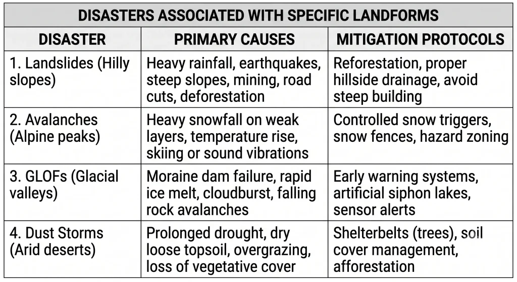
- 1. Landslides (भूस्खलन):
- Causes: भारी मूसलाधार बारिश से soil का saturated हो जाना (जिससे friction घटता है और भार बढ़ता है), steep cutting for roads, unregulated mining, और deforestation।
- Vulnerable Areas in India: Himalayas और Western Ghats।
- Safety Protocols: ढलानों पर मलबा खिसकने की आवाज़ सुनते ही तुरंत valley floor से दूर ऊँचे safe स्थान पर जाएँ; गिरे हुए electric poles को न छुएं।
- 2. Avalanches (हिमस्खलन):
- Causes: पर्वतीय ढलानों पर कमजोर बर्फ की परतों (weak snowpack) पर भारी ताज़ा बर्फ गिरना, sudden temperature rise जिससे पिघलन हो, या mountaineering/explosions से उत्पन्न vibrations।
- 3. Glacial Lake Outburst Floods (GLOFs):
- Causes: High-altitude moraine-dammed glacial lakes का अचानक टूटना। Climate change और global warming के कारण glaciers तेजी से पिघलते हैं, जिससे इन झीलों में जलस्तर खतरनाक रूप से बढ़ जाता है। Avalanche या landslide गिरने से moraine dam फट जाता है और downstream भीषण बाढ़ आती है।
- Real Event: Chamoli Disaster, Uttarakhand (February 2021)—जहाँ sudden glacial flood ने bridges, roads और hydro-electric projects (Rishiganga & Tapovan) को भारी क्षति पहुंचाई।
- 4. Dust Storms (धूल भरी आंधियाँ):
- Causes: शुष्क मरुस्थलीय क्षेत्रों में लंबे समय तक सूखा पड़ना, sparse vegetation cover, overgrazing, और dry loose sand को शक्तिशाली तूफानी हवाओं द्वारा atmospheric circulation में उठा लेना।
6. High-Yield Exam Pointers (CBSE Format)
- Key Scientist / Theorist: Theory of Plate Tectonics किसने दी? — W.J. Morgan.
- Crucial 3-Marker Distinction: Weathering vs. Erosion
- Weathering: Rocks का in-situ (स्वस्थानिक) breakdown बिना किसी movement के।
- Erosion: Broken sediments का dynamic movement through running water, wind, glaciers, or sea waves.
- Important Diagnostic Features (1 Mark):
- Crescent-shaped dune with horns facing downwind: Barchan.
- Streamlined rock ridges carved parallel to prevailing wind: Yardang.
- Cave formation rising vertically from the ground floor: Stalagmite.
- Cave formation hanging downward from the ceiling: Stalactite.
- Isolated rock pillar formed after a sea arch collapses: Sea Stack.
- Repeated 5-Marker: “Explain the three types of plate boundaries and describe the landforms associated with each.” (Must cite: Convergent → Himalayas; Divergent → Mid-Atlantic Ridge; Transform → San Andreas Fault).