Class 9 Social Science Part 2 Chapter 1 Revision Notes: Oceans and Life
1. Introduction & Ocean Relief (परिचय और महासागरीय उच्चावच)
Oceans (महासागर) हमारी पृथ्वी के ज़्यादातर हिस्से को cover करते हैं और अपने अंदर कई secrets छुपाए हुए हैं। Indian culture में, ocean को commonly Samudra कहा जाता है, जिसे powerful और sacred माना जाता है और यह stories और rituals में prominently feature होता है。
Just like land पर mountains, valleys और plains होते हैं, ocean floor के भी कई landforms होते हैं। इन सभी underwater features को together submarine relief या ocean relief कहा जाता है। इनमें underwater mountains, plateaus, और trenches शामिल हैं (e.g., Mariana Trench, Mid-Ocean Ridge)。
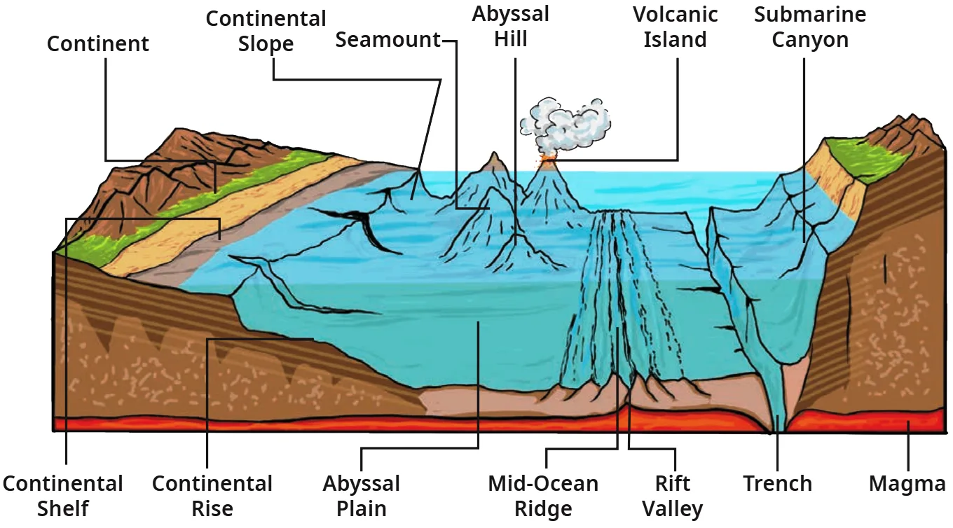
Important Submarine Relief Features:
- Continental Shelf: यह continent का submerged, shallow edge होता है जो marine life और resources (जैसे oil और gas) में rich होता है।
- Continental Slope: यह steep slope होता है जो continent के true edge को mark करता है।
- Abyssal Plain: यह vast, flat, और deep ocean floor होता है।
- Mid-Ocean Ridge: यह volcanic activity से बनी एक immense underwater mountain range होती है।
- Ocean Trenches: ये ocean के deepest parts होते हैं।
📚 Important Definitions
Seamount: एक underwater mountain (usually volcanic origin का) जो ocean floor से उठता है लेकिन sea surface तक नहीं पहुँचता。
Guyot: एक flat-topped underwater mountain, जो usually एक former seamount होता है जिसकी summit erode होकर बाद में submerge हो गई。
🔍 Let’s Explore
Looking at Fig. 1.2:
- How do you think these oceanic features would have been formed?
- Which part of the ocean floor appears deep and shallow?
- How do you think these underwater features would have an effect on marine life and ocean movements?
1. These features form due to tectonic plate movements, volcanic activity (like Mid-Ocean Ridges), and millions of years of deposition and erosion.
2. The Continental Shelf is the shallowest part, while the Ocean Trenches and Abyssal Plains are very deep.
3. Shallow shelves receive sunlight, supporting rich marine life and corals. Deep ridges and trenches host unique ecosystems. These features also act as physical barriers that shape the direction of ocean currents.
🎯 Competency-Based Questions (CBSE Level)
Q1. [Case-Based] A deep-sea exploration team maps a massive, flat region of the ocean floor that lies far beyond the continental margin. Which specific submarine relief feature are they navigating over?
Ans: Abyssal Plain.
Q2. [Application] Scientists discover an underwater mountain with a completely flat top. Based on geographical definitions, what should this landform be classified as, and how was it formed?
Ans: It is classified as a Guyot. It was originally a seamount (volcanic mountain) whose summit eroded over time due to wave action and was later submerged.
Q3. [Assertion-Reason] Assertion (A): Countries mostly drill for oil and natural gas on the Continental Shelf.
Reason (R): The Continental Shelf is the deepest part of the ocean, where decayed matter settles.
Ans: A is correct but R is incorrect. The Continental Shelf is actually the submerged, shallow edge of the continent, not the deepest part, though it is indeed rich in resources like oil and gas.
Q4. [Matching] Match the following oceanic features with their characteristics:
(a) Mariana Trench – (i) Volcanic underwater mountain range
(b) Mid-Ocean Ridge – (ii) Deepest place on Earth
(c) Continental Slope – (iii) Marks the true edge of a continent
Ans: (a)-(ii), (b)-(i), (c)-(iii).
Q5. [Analytical] Why are Seamounts and Guyots different even though they are both underwater mountains?
Ans: A seamount has a peaked or rugged summit that does not reach the surface, whereas a Guyot is a former seamount whose summit was flattened by erosion before being submerged.
2. Movement of Ocean Water (महासागरीय जल की गति)
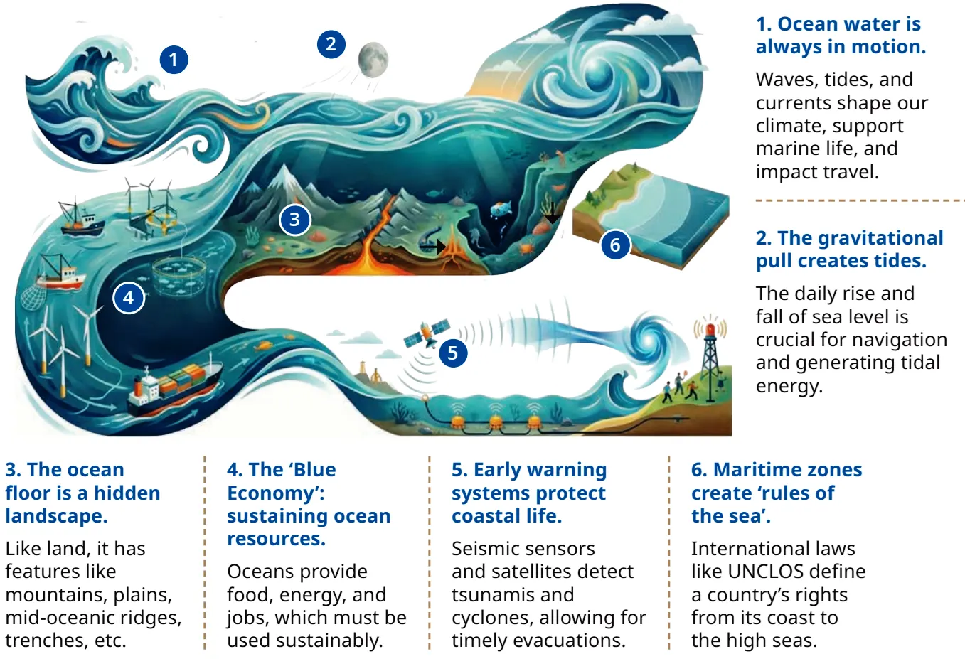
Ocean का water हमेशा motion में रहता है। Waves, tides, और currents Earth’s surface को shape करते हैं, marine life को support करते हैं, fishing और travel में help करते हैं, और climate को influence करते हैं。
2.1 Waves (लहरें)
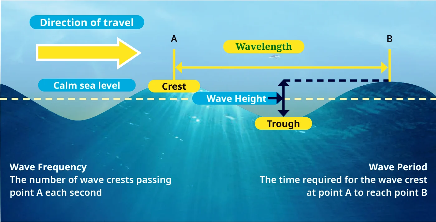
जब ocean का surface alternately rise और fall होता है, तो उसे wave कहते हैं। Waves primarily winds के कारण होती हैं जो water के ऊपर blow करती हैं。
- Components: इनमें Crests (high peaks) और troughs (lower valleys) होते हैं।
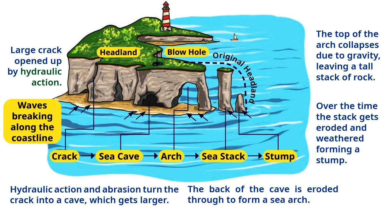
- Waves को coastal architects भी कहा जाता है क्योंकि ये erosion और sediment transport के ज़रिए shoreline को shape करती हैं (e.g., sea caves, arches, stacks, beaches)。
📚 Important Definitions
Wavelength: दो consecutive wave crests या troughs के बीच की horizontal distance。
Hydraulic action: Moving water की force से होने वाला rock और soil का erosion, जो material को loosen और remove कर देता है。
🔍 Let’s Explore
Find out the names of some famous sea beaches in our country and locate them on the map of India。
2.2 Tides (ज्वार-भाटा)
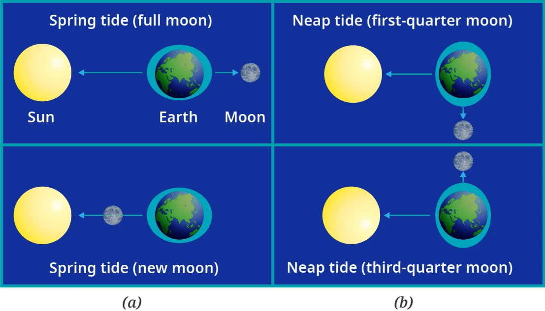
Tides ocean water का rhythmic rise और fall है जो दुनिया के ज़्यादातर हिस्सों में twice a day होता है। ये Sun और Moon के gravitational pull के कारण होते हैं。
- High tide (flood tide): जब water अपने highest level पर rise होता है और shore को cover करता है।
- Low tide (ebb tide): जब water अपने lowest level पर fall होता है।
- Spring Tides: Full moon और new moon days पर, जब Sun, Earth, और Moon एक straight line में align होते हैं। Combined gravitational pull के कारण unusual heights के high tides और unusually lower low tides create होते हैं।
- Neap Tides: जब Moon अपने first और third-quarter phases में होता है, तो Sun और Moon का pull different directions में act करता है, जिससे high और low tide का difference smaller हो जाता है।
💡 Don’t Miss Out
The Bhadkeshwar Mahadev Temple in Dwarka is situated on a small hillock in the Arabian Sea. Visitors can reach the temple only during low tide, as the stone pathway leading to it is completely submerged during high tide!
2.3 Ocean Currents (महासागरीय धाराएँ)
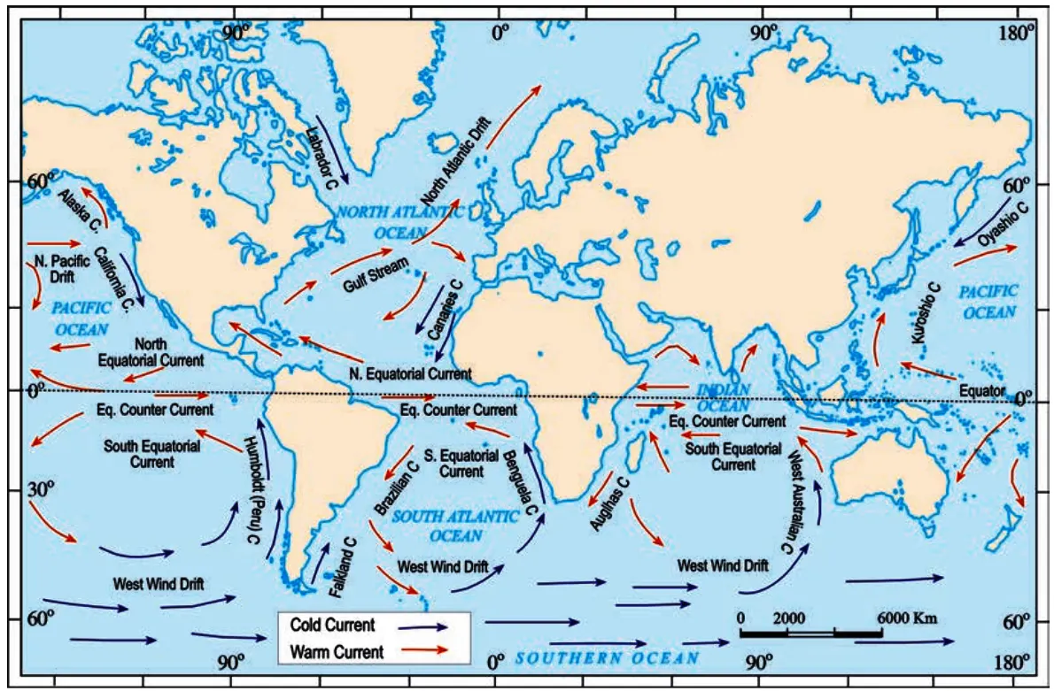
Ocean currents water की continuous streams हैं जो ocean surface पर definite directions में flow करती हैं。
📚 Important Definitions
Coriolis force: Earth की rotation के कारण पैदा होने वाली एक force जो किसी भी free moving object को straight path से deflect कर देती है (Northern Hemisphere में right की तरफ और Southern Hemisphere में left की तरफ)。
- Types:
- Warm currents: Warmer regions से flow करती हैं (e.g., Gulf Stream)。
- Cold currents: Colder regions से flow करती हैं (e.g., Labrador Current)。
💡 More to Know: Fishing Grounds
The regions where warm and cold currents meet are known as fishing grounds. These waters are rich in nutrients, supporting a large variety of fish and making them extremely important for coastal economies。
🤔 Think About It
Observe the map carefully and note the movement patterns of cold and warm currents. Do you think these currents affect the temperature of nearby coastal regions?
🔍 Let’s Explore
Observe Fig. 1.9 and take a note on ocean currents along the coastline of India. What is the nature of ocean currents?
🎯 Competency-Based Questions (CBSE Level)
Q1. [Scenario-Based] A cargo ship of class VLCC needs to safely enter the shallow Singapore Strait. The captain anchors the ship and waits for 4 hours. What specific oceanic movement is the captain waiting for to avoid running aground?
Ans: The captain is waiting for a High Tide (Flood Tide), which raises the water level near the shore and provides the necessary depth for the ship.
Q2. [Analytical] Despite being at a very high latitude (60°-70°), the sea ports in Norway remain free of ice during winter, whereas ports in Canada at similar latitudes freeze. Which oceanic movement causes this temperature difference?
Ans: The warm Gulf Stream current flows towards Norway, keeping its waters relatively warm, preventing ice formation, while the cold Labrador Current flows along Canada’s east coast, bringing freezing water and sea ice.
Q3. [Assertion-Reason] Assertion (A): Sea stacks and stumps are formed along the coast over a long period.
Reason (R): Waves act as coastal architects through continuous hydraulic action and abrasion.
Ans: Both A and R are correct, and R is the correct explanation of A. Waves erode headlands by widening cracks into caves, then arches, and eventually leaving isolated sea stacks and stumps due to gravity and erosion.
Q4. [Conceptual] During which phases of the moon do ‘Neap Tides’ occur, and why are they lower than average high tides?
Ans: Neap tides occur during the first and third-quarter phases of the moon. They are lower because the gravitational pull of the Sun and the Moon act in different (perpendicular) directions, reducing the combined pulling force on the ocean water.
Q5. [Application] Fishing communities often prefer to cast their nets in areas where warm and cold ocean currents converge. Give a geographical reason to support this practice.
Ans: Regions where warm and cold currents meet are rich in nutrients. This mixing supports the abundant growth of plankton, which attracts a large variety of fish, making them excellent and highly productive fishing grounds.
3. Cyclones and Tsunamis – Early Warning Systems (चक्रवात और सुनामी – पूर्व चेतावनी प्रणाली)
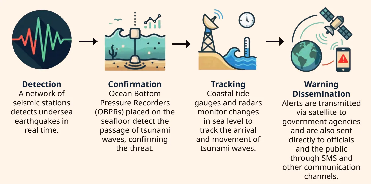
Oceans sudden natural hazards create कर सकते हैं जैसे cyclones (warm ocean waters के ऊपर large rotating storms) और tsunamis (underwater earthquakes से पैदा होने वाली giant waves)। इनसे बचने के लिए scientists ने Early Warning Systems develop किए हैं जो giant alarm systems की तरह काम करते हैं。
- India advanced technologies का use करता है। INCOIS और IMD ने Indian coasts के लिए Storm Surge Early Warning System (SSEWS) establish किया है।
- Tsunamis coastal areas पर पहुचते ही 30 metres या उससे भी ज़्यादा की run-up height (maximum vertical height above sea level) attain कर सकती हैं।
📚 Important Definitions
Bathymetry: Water bodies जैसे oceans, rivers, और lakes की underwater topography (गहराई और आकार) की study और mapping को Bathymetry कहते हैं。
🔍 Let’s Explore
Most deaths during the 2004 Indian Ocean tsunami occurred in Indonesia. However, the Island of Simeulue was largely spared. Researchers suggest that this was partly because of local folklore, passed down through generations, that helped residents recognise the warning signs. Talk to your elders and find out whether similar folk traditions or stories related to natural disasters exist in your culture。
💡 Lifesaving Tech & History
GEMINI Device: The GAGAN-Enabled Mariner’s Instrument for Navigation and Information (GEMINI) एक handheld device है जो fishermen की safety के लिए design किया गया है। यह GAGAN satellite से data receive करके Bluetooth के ज़रिए fishermen के mobile phones पर 9 regional languages में cyclone warnings, high waves alerts, और potential fishing zone advisories भेजता है!
2004 Indian Ocean Tsunami: 26 December 2004 को आए tsunami ने भारी तबाही मचाई थी (around 2,30,000 lives lost)। इसके बाद India ने Indian Tsunami Early Warning Centre (ITEWC) के initiative के under tsunami detection buoys का एक real-time network set up किया है जो tsunamis को detect और measure करता है!
🤔 Think About It
If you receive a tsunami or cyclone alert on your phone right now, do you know the five steps your family should take to stay safe?
- Stay calm and tune in to official radio/TV broadcasts for instructions.
- For a Tsunami: Move immediately to higher ground or inland, away from the coast.
- For a Cyclone: Secure loose outdoor objects, board up windows, and stay indoors in the strongest part of the house.
- Keep an emergency survival kit ready (food, water, torch, first-aid, medicines, important documents).
- Do not go near the beach to watch the waves, and do not return until authorities declare it officially safe.
🎯 Competency-Based Questions (CBSE Level)
Q1. [Case-Based] A fishing boat is 45 nautical miles out in the sea when a severe cyclone begins forming. Which specific handheld device, financially supported by the PMMSY, can help the crew receive satellite alerts on their mobile phones in their local language?
Ans: The GEMINI (GAGAN-Enabled Mariner’s Instrument for Navigation and Information) device.
Q2. [Fact-Based] After a major underwater earthquake, real-time alerts need to be sent to coastal authorities in India. Which nodal centre is primarily tasked with sending these tsunami alerts to the government?
Ans: The Indian Tsunami Early Warning Centre (ITEWC).
Q3. [Assertion-Reason] Assertion (A): Traditional folklore helped save many lives on the Island of Simeulue during the 2004 Tsunami.
Reason (R): Early Warning Systems and modern technology are useless against tsunamis.
Ans: A is correct but R is incorrect. While traditional knowledge saved lives, modern Early Warning Systems (like detection buoys and satellite alerts) are crucial and highly effective for timely evacuations across large coastlines today.
Q4. [Analytical] Cyclones in the North Indian Ocean are named sequentially from a list submitted by 13 member countries. Give one reason why this naming system is important.
Ans: The naming system aids in clear communication, avoids confusion when multiple storms exist simultaneously, and increases public awareness for efficient disaster management and evacuation.
Q5. [Application] To protect coastal communities, INCOIS and IMD established the SSEWS. What specific threat does this system forecast?
Ans: The Storm Surge Early Warning System (SSEWS) forecasts cyclone-induced storm surges and predicts the extent of coastal inundation (flooding).
4. Marine Resources and Their Significance (समुद्री संसाधन और उनका महत्व)
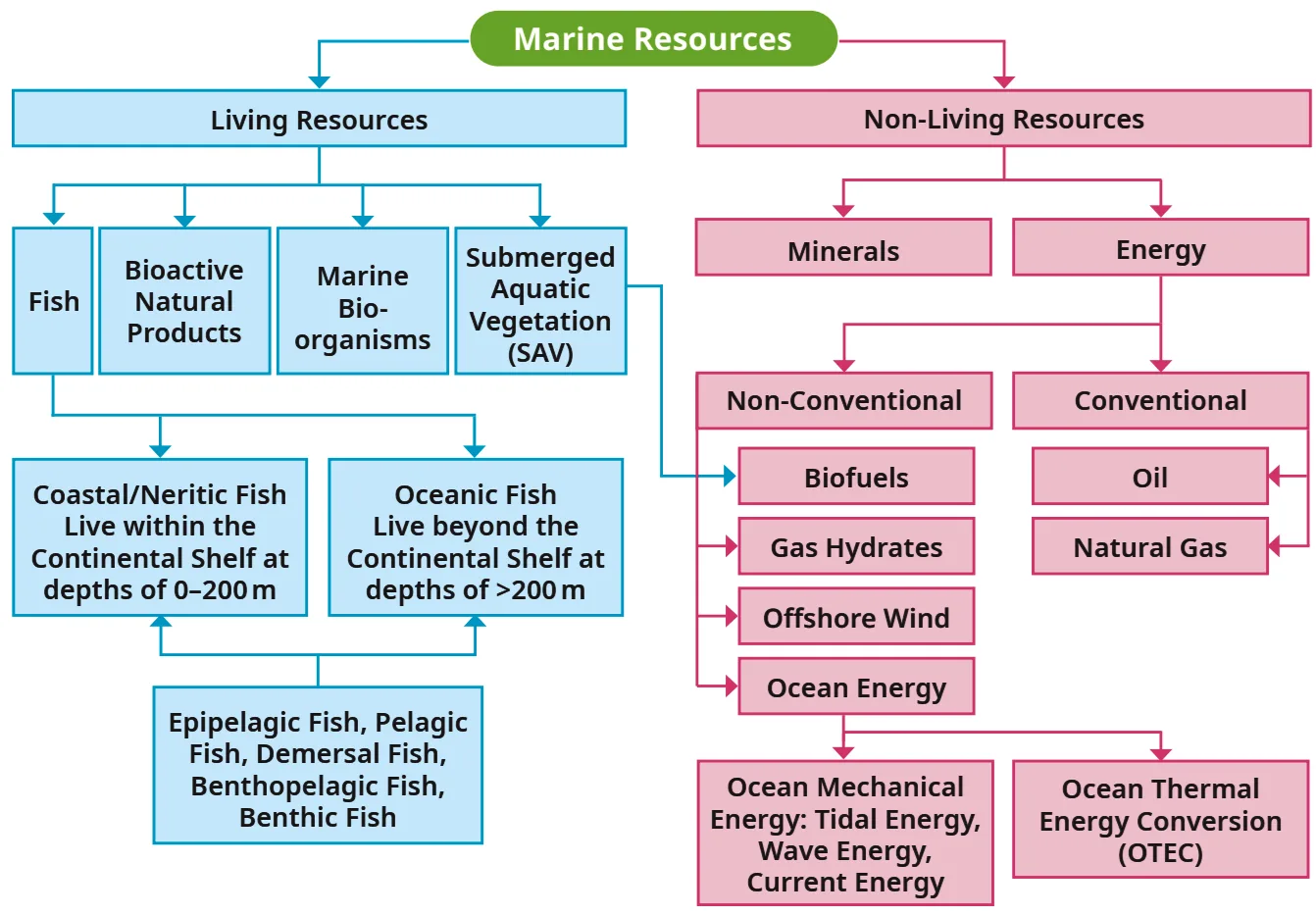
Oceans resources के vast storehouses हैं। Oceans में पाई जाने वाली materials और features जिनकी intrinsic या economic value होती है, उन्हें marine resources कहा जाता है。
Classification:
- Living Resources: Fish (Coastal/Neritic & Oceanic), bioactive natural products, marine bio-organisms, submerged aquatic vegetation (SAV)。
- Non-Living Resources:
- Minerals (sand, gravel, deep-sea minerals)
- Energy: Conventional (Oil, Natural Gas) and Non-Conventional (Biofuels, Gas Hydrates, Offshore Wind, Ocean Energy like Tidal/Wave and OTEC)。
Significance: ये food security, economic activities, trade (global trade का 90% sea द्वारा होता है), tourism, और cultural significance (जैसे sacred shankha/cowrie shells) के लिए vital हैं。
💡 Don’t Miss Out: The Blue Economy (नीली अर्थव्यवस्था)
World Bank के according, Blue Economy का मतलब है “ocean resources का sustainable use ताकि economic growth, improved livelihoods, और jobs को promote किया जा सके, जबकि marine ecosystem की health को preserve किया जाए”। यह concept UN’s Sustainable Development Goal (SDG) 14: Life Below Water में enshrined है!
🎯 Competency-Based Questions (CBSE Level)
Q1. [Case-Based] A coastal nation decides to expand its offshore oil drilling operations while simultaneously enforcing strict laws to protect local coral reefs, regulate fishing limits, and reduce marine pollution. Which global development concept defined by the World Bank are they implementing?
Ans: The Blue Economy.
Q2. [Classification] Based on the classification of marine resources, categorize the following items into Living or Non-Living resources: (a) Gas Hydrates, (b) Bioactive Natural Products, (c) Offshore Wind, (d) Epipelagic Fish.
Ans: Living Resources: Bioactive Natural Products, Epipelagic Fish. Non-Living Resources: Gas Hydrates, Offshore Wind.
Q3. [Assertion-Reason] Assertion (A): Oceans are vital for global commerce and international trade.
Reason (R): 90% of global trade by volume is carried by sea.
Ans: Both A and R are correct, and R is the correct explanation of A.
Q4. [Analytical] How does the concept of the Blue Economy connect to the UN’s Sustainable Development Goal (SDG) 14?
Ans: The Blue Economy is enshrined in SDG 14: “Life Below Water.” Both share key aims such as reducing marine pollution, protecting marine ecosystems, addressing ocean acidification, and regulating fishing to preserve ocean health while promoting economic benefits.
Q5. [Application] Mention two ways in which ocean resources hold deep cultural significance in Indian traditions.
Ans: Ocean resources like the sacred shankha (conch) and kapardikā (cowrie shells), considered divine treasures from the mythological Samudra Manthana, feature prominently in stories, rituals, and historical currencies.
5. Maritime Zones and Rules (समुद्री क्षेत्र और अंतर्राष्ट्रीय नियम)
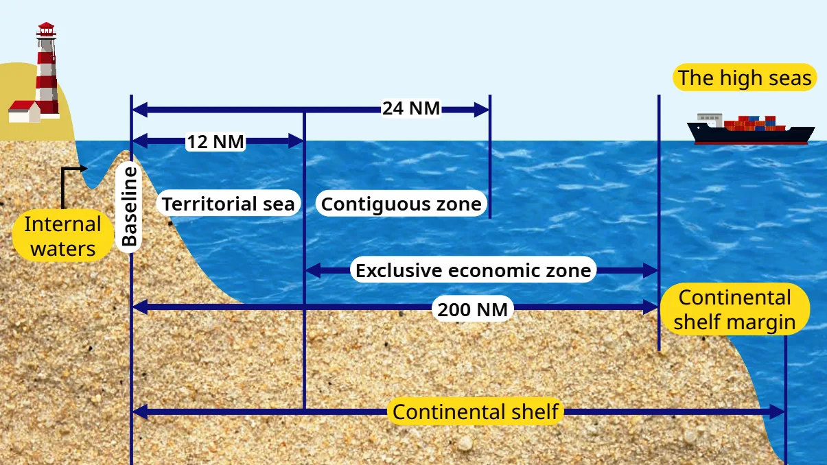
Oceans को international law द्वारा different areas में divide किया गया है, जिन्हें maritime zones कहते हैं。
📚 Important Definitions
Nautical mile (NM): Maritime और air navigation में use होने वाली measurement unit, जो exactly 1,852 metres के बराबर होती है (based on Earth’s circumference)。
Innocent Passage: एक principle जो foreign ships को किसी country के territorial waters से continuously pass होने की permission देता है, as long as वे peace, good order या security को threaten ना करें। (Fishing, military operations, or stopping are not allowed unless in emergencies)。
- Territorial Waters: Country के baseline से सबसे close sea area (upto 12 Nautical Miles)。 Country का near-complete control होता है (customs, pollution laws), subject to innocent passage。
- Contiguous Zone: Baseline से 24 NM तक, जहाँ country का customs, fiscal matters, और illegal immigration पर limited control होता है।
- Exclusive Economic Zones (EEZs): Baseline से 200 NM तक (defined under UNCLOS)。 Country को ocean resources (fish, oil, gas) use करने के special rights होते हैं, but it doesn’t fully own the waters。
- The High Seas (International Waters): EEZs के beyond का area, जो world’s oceans का about 64% cover करता है। ये global commons हैं जहाँ सभी countries को equal rights (navigation, fishing, laying cables) मिलते हैं। यहाँ ship के register होने वाले “flag state” के laws apply होते हैं।
International Maritime Rules and Regulations
Sea पर activities safe, fair और peaceful रहें, इसके लिए countries international maritime laws follow करते हैं。
- COLREGS (Convention on the International Regulations for Preventing Collisions at Sea): ये ships के लिए “rules of the road at sea” हैं जो accidents prevent करते हैं (e.g., maintaining proper lookout, safe speed, using lights/signals)。
- MARPOL (International Convention for the Prevention of Pollution from Ships): यह agreement ships से होने वाले pollution को कम करने और marine environment को protect करने के लिए है।
🔍 Let’s Explore
Maritime disputes are conflicts or disagreements between countries over territory, resources, or rights in naval areas… Can you find out some countries that have conflicts over their territorial sea waters?
🎯 Competency-Based Questions (CBSE Level)
Q1. [Scenario-Based] A country wants to build an offshore oil rig 150 nautical miles away from its coastline. Under which maritime zone does this fall, and which international agreement grants them the special right to exploit this resource?
Ans: It falls under the Exclusive Economic Zone (EEZ). The United Nations Convention on the Law of the Sea (UNCLOS) grants them the right to use resources up to 200 NM.
Q2. [Application] Two commercial ships are approaching each other in heavy fog on the High Seas. Which specific international regulation dictates which ship should give way to prevent a collision?
Ans: COLREGS (Convention on the International Regulations for Preventing Collisions at Sea).
Q3. [Assertion-Reason] Assertion (A): A foreign merchant ship can sail through India’s territorial waters as long as it does not stop or threaten security.
Reason (R): The principle of Innocent Passage allows for continuous and peaceful transit through territorial waters.
Ans: Both A and R are correct, and R is the correct explanation of A.
Q4. [Analytical] A crime takes place on a cargo ship sailing in the High Seas (international waters). Since no country owns the High Seas, whose laws will apply to solve this crime?
Ans: The laws of the “flag state”—the country in which the ship is officially registered—will apply.
Q5. [Case-Based] An oil tanker is found illegally dumping toxic waste 300 nautical miles offshore. Which international convention is directly violated by this action?
Ans: The MARPOL (International Convention for the Prevention of Pollution from Ships) Convention.
The Big Questions (Chapter Objectives Solved)
1. What is the importance of ocean relief?
2. How does ocean water movement impact life and environment?
3. Why are maritime zones important for a country?
4. How can we use ocean resources in a sustainable way?
5. How do early warning systems help protect people from tsunamis and cyclones?
List
Class 9 Social Science Part 2 Chapter 1 Oceans and Life Revision Notes
Class 9 Social Science (History) — Chapter 4: Early Humans and Beginning of Civilisation
Grade 9 Social Science (Geography) — Chapter 2: Shaping of the Earth’s Surface