Class 9 Social Science Part 2 Chapter 2 Revision Notes: Life on Earth
1. Introduction & Biomes (परिचय और बायोम)
Geography हमें यह समझने में मदद करती है कि कैसे climate, landforms, और water Earth पर life को shape करते हैं—और कैसे humans इन conditions के अनुसार adapt करते हैं। हमारी पृथ्वी को एक giant patchwork quilt की तरह इमेजिन करें, जहाँ हर patch का अपना मौसम और जीव-जंतु होते हैं। इन विशाल patches को Biomes कहा जाता है।
📚 Important Definitions
Biome: Biomes विश्व के विशाल प्राकृतिक क्षेत्र (large natural regions) हैं जहाँ कुछ विशेष प्रकार के plants और animals समान climatic conditions में रहते हैं। ‘Biome’ शब्द bio (जिसका ग्रीक अर्थ है ‘life’) और -ome (biology में एक specific group को दर्शाने वाला suffix) से मिलकर बना है। किसी biome में कौन से जीव पनपेंगे, यह मुख्य रूप से temperature, precipitation patterns, dominant plant species, और growth forms of vegetation पर निर्भर करता है।
Ecosystem: एक Biome के भीतर एक neighbourhood की तरह है, जहाँ plants, animals, और non-living things एक दूसरे के साथ closely interact करते हैं।

🔍 Let’s Map
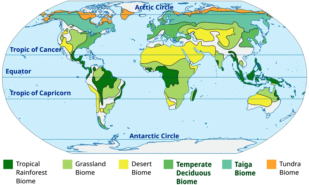
Look at the world map in Fig. 2.2 and answer the following questions.
- Which type of biome is found in smaller, separate regions, and why?
- Which continent has the least number of biomes? What could be the reason for this?
- Why are there areas that do not have any specific biomes?
1. The Temperate Deciduous Biome and Grassland Biomes are often found in smaller, separate regions because they require very specific, moderate climatic conditions that only occur in transitional zones between extreme hot and extreme cold areas.
2. Antarctica has the least number of biomes (primarily just ice/tundra) because of its extreme, continuously freezing climate that prevents diverse plant and animal life from thriving.
3. Some areas (like extreme high mountain peaks or massive ice sheets) do not have specific biomes marked because their conditions are too harsh to support a stable, recognizable biological community (ecosystem).
🎯 Competency-Based Questions (CBSE Level)
Q1. [Conceptual] How is a Biome different from an Ecosystem?
Ans: A biome is a broad, large-scale environmental region (like a desert or tundra) sharing similar climate and life forms. An ecosystem is smaller, acting like a neighborhood within the biome where living and non-living things interact closely.
Q2. [Analytical] Why are biomes considered the “patchwork quilt” of the Earth?
Ans: Because just like a quilt is made of different colored patches, the Earth is made of different biomes (forests, deserts, tundras), each with its own unique weather, plants, and animals that together form the living world.
Q3. [Assertion-Reason] Assertion (A): Biomes are exclusively defined by political boundaries.
Reason (R): Climate, temperature, and precipitation patterns determine the type of biome.
Ans: A is incorrect but R is correct. Biomes are defined by natural factors like climate and vegetation, not political borders.
Q4. [Application] If a scientist is studying the interaction between a specific frog species and a local pond’s water quality, are they studying a biome or an ecosystem?
Ans: They are studying an ecosystem, because it focuses on the close interaction between specific living things and their immediate non-living environment (the pond).
Q5. [Fact-Based] Identify three major factors that determine which types of plants and animals can survive in a specific biome.
Ans: Temperature, precipitation patterns, and the growth forms of dominant plant species.
2. Types of Biomes (बायोम के प्रकार)
Biomes मुख्य रूप से दो प्रकार के होते हैं: Terrestrial Biomes (land-based) और Aquatic Biomes (water-based)।
2.1 Terrestrial Biomes (स्थलीय बायोम)
इन्हें climate के आधार पर Forests, Grasslands, Deserts, और Tundra में classify किया गया है।
A. Forest Biome (वन बायोम)
Forests nature के विशाल हरे छाते (giant green umbrella) की तरह होते हैं। Tropical rainforests मुख्य रूप से Equator के पास (23.5° N से 23.5° S के बीच) पाए जाते हैं जहाँ साल भर गर्मी और बारिश रहती है, जो घने जंगलों को support करती है।
- Major Locations: Amazon Basin (South America), Congo Basin (Africa), Southeast Asia (Indonesia, Malaysia). India में ये Andaman & Nicobar Islands और Northeastern states में मिलते हैं।
- Gene Bank: Rainforests दुनिया का सबसे rich biodiversity storehouse हैं। ये unique genetic material preserve करते हैं (scientific research के लिए), इसलिए इन्हें ‘gene bank’ भी कहा जाता है।
- Importance: ये oxygen levels maintain करते हैं और Earth के climate को balance करते हैं।
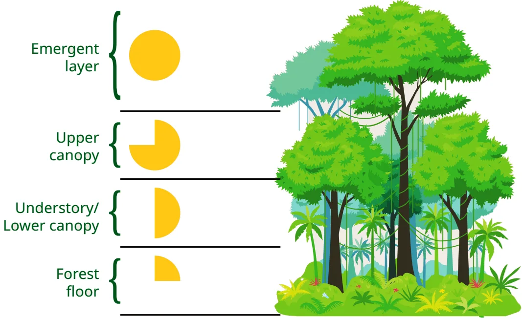
एक Rainforest को 4 मुख्य परतों (layers) में बांटा जाता है:
- Emergent Layer: सबसे ऊपरी परत, जहाँ सबसे ऊंचे पेड़ होते हैं। इन्हें 100% sunlight मिलती है।
- Upper Canopy: घने पत्तों की छतरी जो ज़्यादातर sunlight को block कर देती है।
- Understory / Lower Canopy: यहाँ बहुत कम sunlight पहुँचती है, इसलिए यहाँ बड़े पत्तों वाले पौधे उगते हैं।
- Forest Floor: सबसे निचली परत, जहाँ बिल्कुल भी धूप नहीं पहुँचती। यह dark और damp (नम) होती है।
🔍 Let’s Explore
Look at the layers of vegetation in a rainforest (Fig 2.4). What do the yellow shapes in the figure indicate?
B. Grassland Biome (घासस्थल बायोम)
ये विशाल open areas होते हैं जहाँ मुख्य रूप से घास होती है और बहुत कम पेड़ होते हैं। ये उन regions में विकसित होते हैं जहाँ moderate rainfall होती है, जो घने जंगलों के लिए पर्याप्त नहीं होती।
- Temperate Grasslands: (जैसे North America में prairies और Asia में steppes) यहाँ की मिट्टी उपजाऊ (fertile) होती है और इन्हें farming के लिए इस्तेमाल किया जाता है।
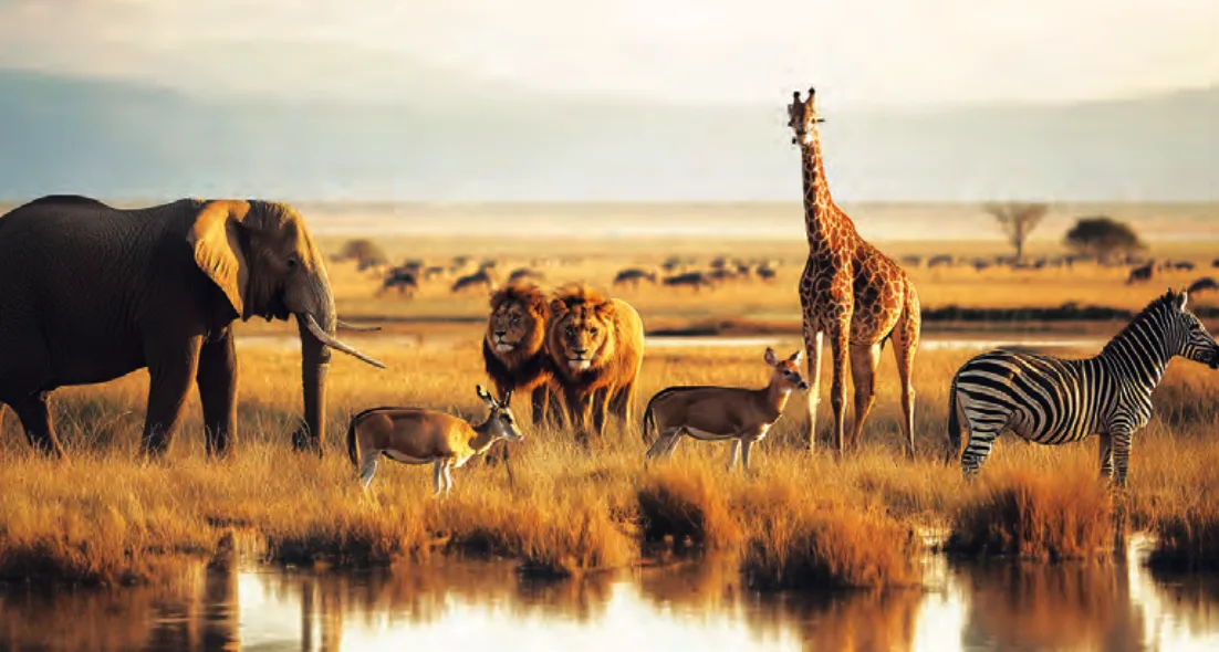
- Tropical Grasslands (Savannas): (जैसे Africa में) यहाँ scattered trees होते हैं और ये lions, elephants, और giraffes जैसे बड़े जानवरों का घर हैं।
🔍 Let’s Explore
Observe Fig. 2.5 and explore which of these animals you will find in the grasslands of India.
C. Desert Biome (मरुस्थलीय बायोम)
Deserts सबसे dry biomes होते हैं जहाँ बहुत कम बारिश होती है। ये Hot (जैसे Africa का Sahara) या Cold (जैसे Asia का Gobi) हो सकते हैं।
- Rann of Kutch: गुजरात का यह दुनिया के सबसे बड़े salt deserts में से एक है। Monsoon में यह marshy wetland बन जाता है और dry season में vast white salt desert.
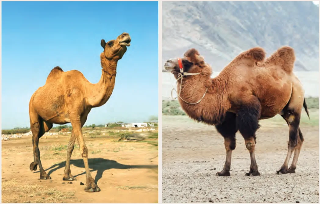
- Adaptation: यहाँ के plants (cacti) और animals (camels, lizards, snakes) पानी store करने और extreme गर्मी सहने के लिए specially adapted होते हैं। यहाँ की मिट्टी रेतीली (sandy) होती है।
🤔 Think About It
Compare the physical features of the Rajasthan camel (Fig. 2.7a) and the Nubra Valley (Ladakh) camel (Fig. 2.7b). Considering the climatic conditions, why do you think the Nubra Valley camel might have a different fur density than the Rajasthan camel?
🔍 Let’s Explore
What types of activities do you think people in desert regions generally undertake to sustain their households and livelihood? With the help of your teacher, explore how do people address issues related to the availability of water.
D. Tundra Biome (टुंड्रा बायोम)
यह सबसे ठंडा biome है जो Arctic और Antarctic regions के पास पाया जाता है। यहाँ सर्दियाँ बहुत लंबी और कठोर होती हैं, और गर्मियां बहुत छोटी।
- Permafrost: यहाँ की मिट्टी साल भर जमी रहती है, जिसे permafrost कहते हैं, जिससे यहाँ पेड़ों का उगना मुश्किल होता है।
- Flora & Fauna: यहाँ vegetation mosses, lichens, और small shrubs तक सीमित है। Animals जैसे reindeer, arctic foxes, और polar bears यहाँ पाए जाते हैं। यह ecosystem बहुत fragile होता है, छोटे से तापमान परिवर्तन से भी इसे नुकसान हो सकता है।
📚 Important Definitions
Temperate deciduous biome: यह biome चौड़ी पत्तियों वाले (broad-leaved) पेड़ों के जंगलों की विशेषता है जो मौसमी रूप से (seasonally) अपने पत्ते गिराते हैं, यहाँ moderate temperatures और distinct seasons होते हैं。
Taiga biome: यह biome शंकुधारी वनों (coniferous forests) की विशेषता है जिसमें मुख्य रूप से pines, spruces, और larches होते हैं。
🤔 Think About It
Tundra in polar regions has mosses, lichens, shrubs, etc., while the Himalaya, in the subtropics, is dominated by conifers. What could be the reason for this? What difference do you find in the animals found in these two regions? Which species are found only in the Himalaya?
2.2 Aquatic Biomes (जलीय बायोम)
ये Earth के surface का लगभग three-fourths (3/4) हिस्सा cover करते हैं। इन्हें दो भागों में बांटा गया है:
- Freshwater Biomes: इनमें नदियां (rivers), झीलें (lakes), तालाब (ponds), और wetlands शामिल हैं। ये agriculture, पीने के पानी (drinking water), और species (fish, frogs) को support करने के लिए crucial हैं।
- Marine Biomes: इनमें oceans, seas, और coral reefs शामिल हैं। ये biodiversity में rich होते हैं और Earth के climate को heat store और distribute करके control करते हैं।
🔍 Let’s Explore
Explore your local environment. Observe how people, plants, and animals build structures and interact. Complete the table with your findings.
– Trees/Plants: Neem, Mango (Provide shade and fruits for humans/birds).
– Insects: Bees, Butterflies (Help in pollinating local gardens).
– Animals: Dogs, Cows (Domesticated by humans for companionship and milk).
– Non-living things: Ponds, Soil (Provide water and a base for agriculture).
🎯 Competency-Based Questions (CBSE Level)
Q1. [Assertion-Reason] Assertion (A): Tropical rainforests are often referred to as ‘gene banks’.
Reason (R): They possess the world’s richest biodiversity and preserve unique genetic material useful for conservation and scientific research.
Ans: Both A and R are correct, and R is the correct explanation of A.
Q2. [Case-Based] A farmer lives in a region with moderate rainfall, vast open flat lands, and highly fertile soil, completely devoid of tall trees. He uses large machinery to farm wheat. Which biome does he live in?
Ans: Temperate Grassland Biome.
Q3. [Analytical] Why are tall trees completely absent in the Tundra Biome?
Ans: Trees are absent because the soil remains permanently frozen year-round (a condition known as permafrost), preventing deep tree roots from growing and absorbing necessary nutrients.
Q4. [Matching] Match the biome with its characteristic feature:
(a) Tropical Rainforest – (i) Scattered trees and lions
(b) Savanna – (ii) Permafrost
(c) Tundra – (iii) Four distinct layers of vegetation
Ans: (a)-(iii), (b)-(i), (c)-(ii).
Q5. [Application] If global warming severely raises ocean temperatures, which specific aquatic biome structure would be most immediately endangered, affecting countless marine species?
Ans: Coral reefs within the Marine Biome would be immediately endangered due to coral bleaching.
3. Biome Pyramid & Interconnectedness (बायोम पिरामिड और अंतर्संबंध)
3.1 Biome Pyramid
Biome pyramid एक graphical representation है जो एक biome के भीतर विभिन्न जीवों (organisms) के बीच के relationship को दर्शाता है (usually energy, number, या biomass के terms में)।
- Base (Producers): पिरामिड के आधार पर plants और algae होते हैं जो photosynthesis के ज़रिए solar energy capture करते हैं।
- Upper Levels (Consumers): इसके ऊपर herbivores (primary consumers), carnivores (secondary consumers), और top predators (tertiary consumers) आते हैं।
- जैसे-जैसे हम पिरामिड में ऊपर जाते हैं, जीवों की संख्या (number), biomass, और available energy decrease होती है, क्योंकि हर level पर metabolic processes के दौरान heat के रूप में energy lost हो जाती है।
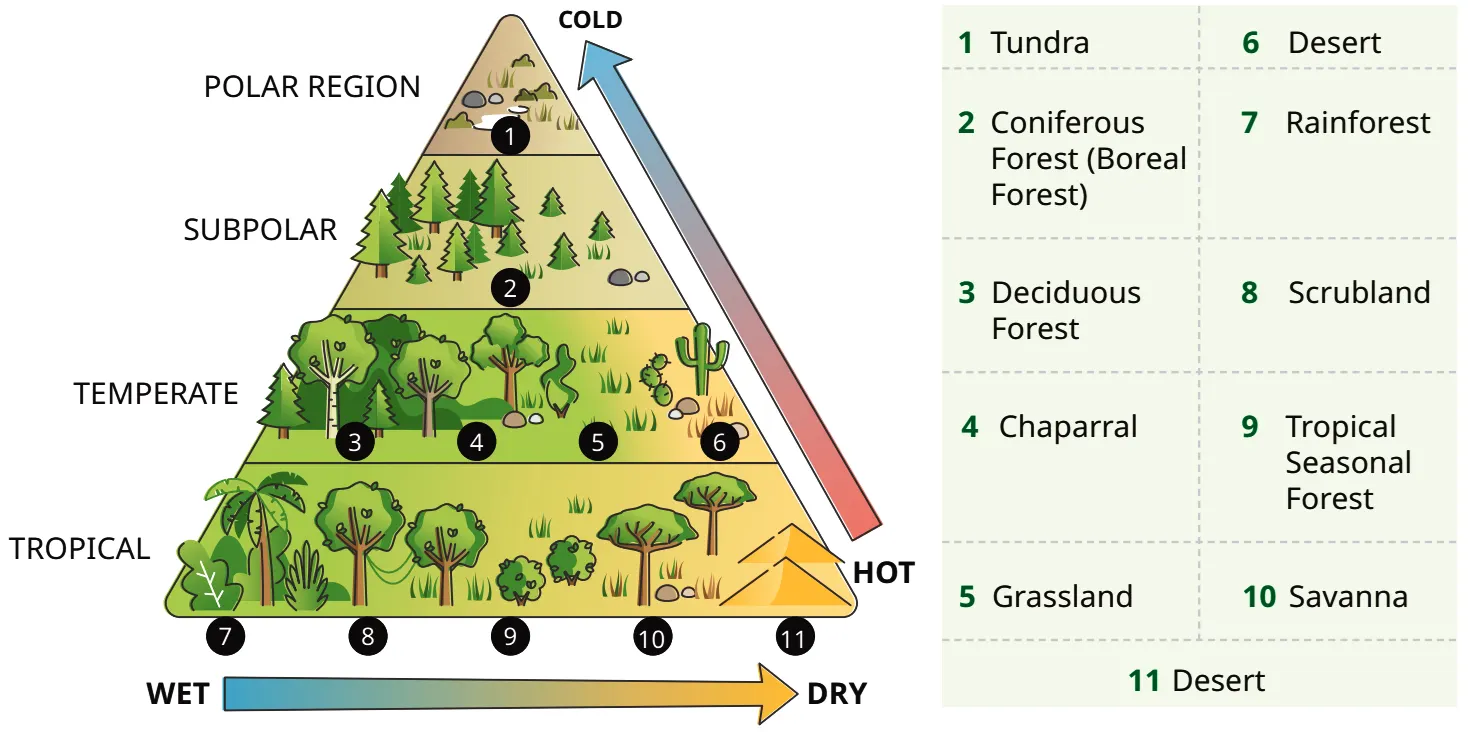
Biome पिरामिड दो महत्वपूर्ण climatic gradients को दर्शाता है:
- Wet to Dry (X-Axis): आधार (base) पर बाईं ओर सबसे गीले (Wet) क्षेत्र हैं जैसे Rainforests, और दाईं ओर सबसे सूखे (Dry) क्षेत्र हैं जैसे Deserts.
- Hot to Cold (Y-Axis): नीचे से ऊपर जाने पर तापमान घटता है (Hot to Cold)। सबसे नीचे Tropical (गर्म), बीच में Temperate, और सबसे ऊपर Polar/Tundra (ठंडा) क्षेत्र हैं।
🔍 Let’s Map
Mark regions on Fig. 2.10: Andaman & Nicobar Islands, Keralam, Ladakh, Chhattisgarh, Odisha, Meghalaya, and Lakshadweep. Where will you place your home? There is no arrow on the third side of the triangle. What would happen if we drew an arrow? Would it point upwards or downwards?
3.2 Maintaining Ecological Balance and Biodiversity
Biomes और living beings आपस में गहराई से जुड़े हुए हैं। Animals pollination में मदद करते हैं, humans landscapes modify करते हैं, और microorganisms nutrients recycle करते हैं।
📚 Important Definitions
Biodiversity (जैव विविधता): Earth पर जीवन की विविधता, जिसमें plants, animals, microorganisms, और उनके ecosystems शामिल हैं। यह न केवल species की संख्या है, बल्कि उनके भीतर के genetic differences भी हैं। यह healthy ecosystems और human survival के लिए ज़रूरी है।
Conservation के कुछ प्रमुख पहलू (Key aspects of conservation):
- Hotspots of Biodiversity: ये वो क्षेत्र हैं (जैसे Himalaya, Western Ghats, North-East India, Andaman & Nicobar) जो unique species में rich हैं जो कहीं और नहीं पाए जाते।
- Ecosystem-Based Conservation: Conservation strategies भौगोलिक स्थिति के अनुकूल होनी चाहिए (e.g., coasts पर mangroves बचाना, पहाड़ों पर afforestation करना)।
- Protected Areas: National parks, wildlife sanctuaries, biosphere reserves, और World Heritage Sites को critical habitats बचाने के लिए चुना जाता है ताकि habitat fragmentation को रोका जा सके।
- Geographical Barriers and Corridors: नदियाँ, पहाड़, और घाटियाँ जानवरों के movement और gene flow को प्रभावित करते हैं (as barriers)। Conservation planning में इन्हें जोड़ने के लिए ‘wildlife corridors’ बनाए जाते हैं।
- Human-Environment Interaction: पहाड़ों पर terrace farming या मैदानों में agroforestry जैसे sustainable practices अपनाए जाते हैं।
🔍 Let’s Map
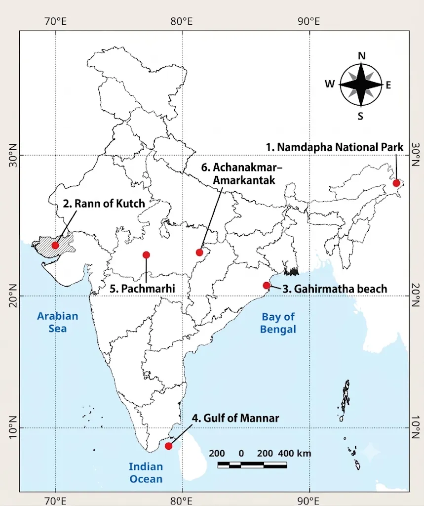
Mark and name the following regions on the map in Fig. 2.13: 1. Namdapha National Park, 2. Rann of Kutch, 3. Gahirmatha beach, 4. Gulf of Mannar, 5. Pachmarhi, 6. Achanakmar-Amarkantak.
1. Namdapha (Arunachal Pradesh)
2. Rann of Kutch (Gujarat)
3. Gahirmatha (Odisha coast)
4. Gulf of Mannar (Tamil Nadu coast)
5. Pachmarhi (Madhya Pradesh)
6. Achanakmar-Amarkantak (Border of MP and Chhattisgarh).
🎯 Competency-Based Questions (CBSE Level)
Q1. [Analytical] In a biome pyramid, why is the base always wider than the top apex?
Ans: The base represents producers (plants), which contain the maximum amount of energy. As energy transfers up to consumers, a large amount is lost as metabolic heat, meaning fewer organisms (biomass) can be supported at the top, making the apex narrow.
Q2. [Case-Based] The Western Ghats contain hundreds of unique plant and animal species found nowhere else on Earth, making it a critical area for global protection. What geographical conservation term is used to describe such regions?
Ans: A Hotspot of Biodiversity.
Q3. [Assertion-Reason] Assertion (A): Wildlife corridors are artificially planned by conservationists.
Reason (R): Natural geographical barriers like rivers and mountains restrict animal movement and gene flow, so corridors help reconnect fragmented habitats.
Ans: Both A and R are correct, and R is the correct explanation of A.
Q4. [Application] If you wanted to practice “Ecosystem-Based Conservation” on a coastline experiencing heavy storm erosion, what natural vegetation would you plant?
Ans: Mangroves, as they are naturally suited for coastal ecosystems and protect shores from erosion.
Q5. [Conceptual] How do microorganisms contribute to the interconnectedness between biomes and living beings?
Ans: Microorganisms break down dead matter and recycle essential nutrients back into the soil, maintaining the ecological balance required for plant growth.
4. Forests, Ecotourism & Communities (वन, इकोटूरिज्म और समुदाय)
4.1 Forest Ecotourism
📚 Important Definitions
Ecotourism: Nature-friendly जगहों पर travel करना जिससे environment को नुकसान न पहुंचे, और जिससे local लोगों को आर्थिक सहायता (support) मिले और ecosystems के बारे में सीखने को मिले।
Forest ecotourism का उद्देश्य है जंगलों की सुंदरता का आनंद लेना और साथ ही conservation में योगदान देना। यह mass tourism से अलग है क्योंकि यह minimal environmental impact और local communities के सम्मान पर ज़ोर देता है। इससे local people के लिए income generate होती है।
💡 Don’t Miss Out
Ministry of Tourism (Govt. of India) ने Swadesh Darshan 2.0 Scheme launch की है, जिसका उद्देश्य sustainable tourism destinations develop करना है जहाँ tourist-centric approach, conservation, और local community involvement पर focus हो。
🔍 Let’s Explore
Thenmala Ecotourism in Keralam: Thenmala (‘Honey Hill’) Kollam district में है और यह India का पहला planned ecotourism destination है। यह Western Ghats (UNESCO World Heritage Site) में स्थित है। यह locals को guides, eco-guards, और service providers बनाकर sustainable tourism promote करता है, जिससे tourism benefits community के भीतर share होते हैं।
Is there any such ecotourism site in your State/UT?
🤔 Think About It
What should be a tourist’s behaviour while visiting any tourist site? What should one be mindful of?
4.2 Forests and Livelihoods (वन और आजीविका)
Rural और tribal communities अपनी आजीविका (livelihoods) के लिए जंगलों पर बहुत ज़्यादा निर्भर करते हैं। उन्हें जंगलों से भोजन, ईंधन (fuelwood), चारा (fodder), दवाएं, और Non-Timber Forest Products (NTFPs) जैसे शहद, बांस, और रेजिन मिलते हैं। Gonds और Bhils जैसे समुदाय संसाधनों को इकट्ठा करने से पहले वन देवताओं (forest deities) का सम्मान करते हैं, जो nature के प्रति deep respect को दर्शाता है।
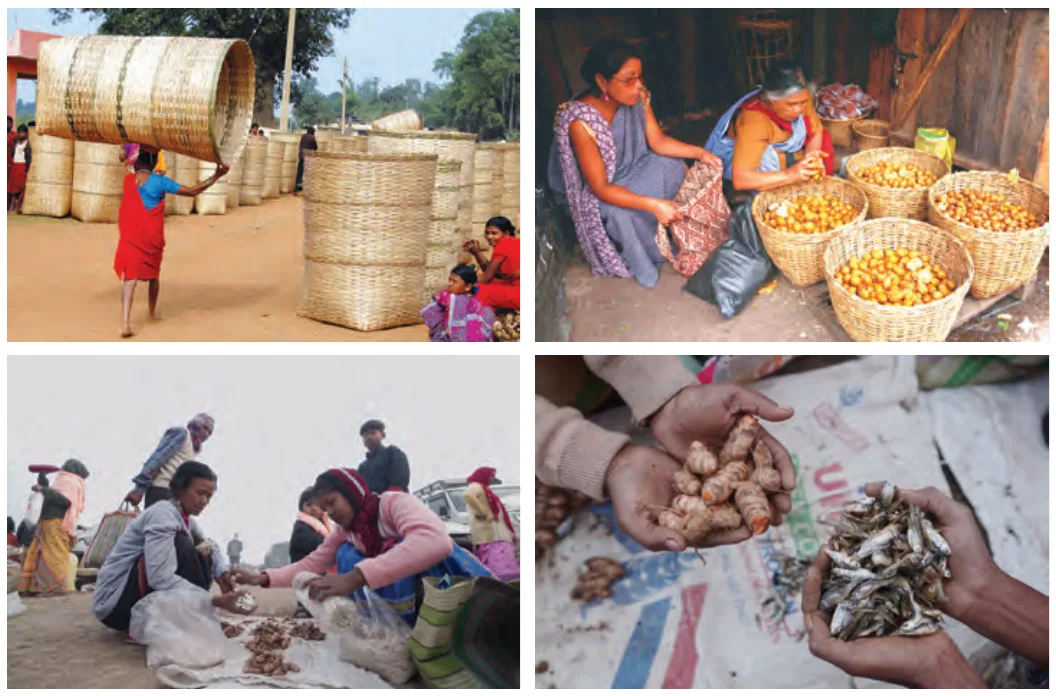
🔍 Let’s Explore
Try to identify and classify the items for sale in the traditional tribal livelihood images (Fig. 2.18). Also, make a list of the food and medicinal varieties available in your local market.
Local Market Varieties: In local markets, one can typically find forest-derived foods like honey, mushrooms, tamarind, and medicinal varieties like neem, tulsi, ashwagandha, and amla.
🤔 Think About It
Sacred Groves: Sacred groves small forest patches होते हैं जिन्हें स्थानीय समुदाय धार्मिक और सांस्कृतिक (religious and cultural) कारणों से बचा कर रखते हैं। भारत में 1,00,000 से अधिक sacred groves हैं (e.g., Devrai, Devarakadu, Kavu, Sarna)। Why are these groves so special?
4.3 Geographical Indication (GI)
📚 Important Definitions
Geographical Indication (GI) tag: यह एक intellectual property right है जो यह identify करता है कि एक product किसी विशिष्ट स्थान (specific region) से आता है और उसकी quality, reputation या अन्य विशेषताएँ उस भौगोलिक उत्पत्ति (geographic origin) से जुड़ी हैं।
GI-tagged Forest Products in India:
- Ramban Sulai Honey (J&K): Strong antioxidant potential, distinct flavour.
- Tezpur Litchi (Assam): Forest-influenced soil में उगाई जाती है, bright colour.
- Channapatna Toys (Karnataka): Wrightia tinctoria (‘Aale mara’) नामक forest tree से बनाए जाते हैं।
- Kandhamal Haldi (Odisha): Tribal communities द्वारा उगाई जाती है, high curcumin content और medicinal value.
- Erode Manjal / Turmeric (Tamil Nadu): Forest-influenced soils में cultivation.
- Nilgiri Tea (TN, Kerala, Karnataka): Western Ghats के forest ecosystem पर निर्भर।
- Tripura Queen Pineapple (Tripura): Forest-dependent cultivation, famous for sweetness.
- Khasi Mandarin (Meghalaya): Forest-rich hills का citrus fruit.
🔍 Let’s Explore
Can you explain how GI tagging of the forest products connects geography, cultural traditions, local governance, and rural economy?
🎯 Competency-Based Questions (CBSE Level)
Q1. [Case-Based] A village in the Western Ghats decides to open its forest to tourists. However, they strictly ban plastic, allow only 50 visitors a day, and hire tribal youth as guides to explain local medicinal plants. What specific type of tourism is this village practicing?
Ans: Ecotourism.
Q2. [Analytical] Why are Non-Timber Forest Products (NTFPs) considered more ecologically sustainable for rural livelihoods than timber extraction?
Ans: Harvesting NTFPs (like honey, resins, or fruits) does not require cutting down the trees, thereby preserving the forest canopy, preventing soil erosion, and maintaining long-term biodiversity.
Q3. [Assertion-Reason] Assertion (A): Sacred groves like ‘Devrai’ and ‘Sarna’ are rich biodiversity hotspots.
Reason (R): Local communities strictly protect these forest patches due to deep religious and cultural beliefs.
Ans: Both A and R are correct, and R is the correct explanation of A.
Q4. [Application] The tribal farmers of Kandhamal grow a specific variety of turmeric that has high medicinal value due to the local forest soil. Which intellectual property tool can the government use to prevent outsiders from selling fake turmeric under this name?
Ans: A Geographical Indication (GI) Tag.
Q5. [Fact-Based] What does ‘Thenmala’, India’s first planned ecotourism destination, literally translate to, and where is it located?
Ans: It translates to ‘Honey Hill’ and is located in the Kollam district of Kerala.
5. Forest Dwellers, Challenges & Ecological Commons (वनवासी, चुनौतियां और पारिस्थितिक कॉमन्स)
5.1 The Deep Connections of Forest Dwellers
वनवासी (Forest Dwellers), विशेषकर महिलाएं, संसाधनों के प्रबंधन में अहम भूमिका निभाती हैं। उनके जंगल के साथ गहरे संबंध (Connections) को 5 मुख्य भागों में बाँटा जा सकता है (Fig. 2.17):
- Livelihood & Income: वे NTFPs (tendu leaves, mahua, honey, lac) gather और process करते हैं।
- Knowledge Holders: उनके पास जड़ी-बूटियों (herbs) और पौधों का पारंपरिक ज्ञान (traditional knowledge) होता है जो पीढ़ियों से चला आ रहा है।
- Forest Protection: वे वनों की रक्षा के लिए हमेशा आगे रहे हैं (जैसे राजस्थान में Amrita Devi द्वारा Bishnoi Movement और उत्तराखंड में Chipko Movement)।
- Household Needs: वे firewood, fodder, roots, और tubers इकट्ठा करते हैं।
- Cultural & Social Role: जंगल उनके rituals, festivals, और beliefs से जुड़े हैं, जो उन्हें ecological guardians बनाते हैं।
5.2 Challenges Faced by Forest Dwellers
वनवासियों को healthcare, education, और clean water जैसी सुविधाओं तक पहुँचने में संघर्ष करना पड़ता है।
- Health Issues: Women अक्सर fuelwood fumes के संपर्क में आती हैं जिससे health problems होती हैं।
- Conflicts: Deforestation और commercial exploitation उनके संसाधनों को सीमित कर देते हैं। जंगली जानवरों (हाथियों, बंदरों, जंगली सूअरों) द्वारा फसल नष्ट करने से human-wildlife conflict होता है।
- Natural Disasters: Hilly regions में floods और landslides का खतरा रहता है।
- Forest Fires: Forest Survey of India (FSI) के अनुसार भारत का लगभग 36% forest cover आग के प्रति संवेदनशील (prone) है, जिसमें से लगभग 4% extremely prone है। Climate change और human factors इसके मुख्य कारण हैं।
🤔 Think About It
Which wild animals have you seen in your residential area? Identify the causes behind these animals’ presence in human settlements.
🔍 Let’s Explore
You may have heard about the Pradhan Mantri Ujjwala Yojana (PMUY). How are the benefits of this scheme impacting the health of women?
5.3 Government Efforts & Community Management
वनवासियों की मदद के लिए सरकार ने Forest Rights Act (FRA), 2006 लागू किया है, जो समुदायों को वन भूमि और संसाधनों पर उनके पारंपरिक अधिकार देता है (e.g., collecting minor produce and owning small cultivated land patches)। Joint Forest Management (JFM) प्रोग्राम स्थानीय समुदायों को वनों की रक्षा करने के लिए प्रोत्साहित करता है। PESA, DAJGUA, और PM JANMAN जैसी अन्य योजनाएं भी उनके कल्याण के लिए हैं।
💡 Case Study: Mendha Lekha
महाराष्ट्र के गड़चिरोली जिले का Mendha Lekha गांव (Gond tribe) भारत का पहला गांव बना जिसे FRA 2006 के तहत वन अधिकारों की मान्यता मिली। यहाँ “Mawa Nate Mawa Raj” (हमारा गांव, हमारा राज) का सिद्धांत चलता है। ग्राम सभा सामूहिक रूप से निर्णय लेती है और 1,800 हेक्टेयर जंगल की रक्षा करती है। वे पेड़ों की कटाई रोकते हैं, आग से बचाते हैं, और bamboo harvest करके उससे कमाए गए पैसे को education में लगाते हैं।
5.4 Ecological Commons (पारिस्थितिक कॉमन्स)
Ecological commons प्राकृतिक संसाधन हैं (जैसे नदियां, झीलें, चरागाह, हवा, biodiversity) जो किसी एक व्यक्ति के स्वामित्व (private property) में नहीं होते, बल्कि पूरी community द्वारा सामूहिक रूप से उपयोग किए जाते हैं।
- Bihar’s Fishery Management: पहले perennial water bodies और diara waterfronts पर ज़मींदारों का कब्ज़ा था, जो fishing community का शोषण करते थे। अब Bihar Fish Jalkar Management Act, 2006 के तहत स्थानीय समुदाय इन संसाधनों का प्रबंधन करते हैं (commons-based model), जिससे मछली उत्पादन में वृद्धि हुई है।
- Water Tanks by Gond Kings: मौसमी बारिश वाले क्षेत्रों में जल प्रबंधन के लिए ऐतिहासिक रूप से कई टैंक बनाए गए। जैसे:
- Bundelkhand में Chandella/Bundela राजाओं द्वारा 8,000 tanks.
- Karnataka में keres.
- Tamil Nadu में eri tanks.
- Andhra Pradesh/Odisha में chevuru tanks.
- Bihar में ahar pynes.
- Gondwana क्षेत्र में Gond राजाओं द्वारा ‘katas’ (three-sided reservoirs).
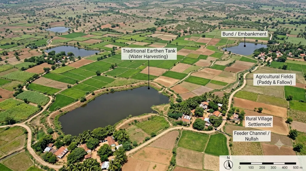
🔍 Let’s Map
Observe Fig. 2.24 (Water tanks in Bhandara district, Maharashtra) carefully and see if you can identify some of the tanks and mark the agricultural fields irrigated by them.
🎯 Competency-Based Questions (CBSE Level)
Q1. [Scenario-Based] A village suffers from continuous leopard attacks on their livestock. Upon investigation, it is found that a large patch of the adjoining forest was cleared for a new highway. What environmental crisis does this scenario depict?
Ans: Human-wildlife conflict caused by habitat destruction and deforestation.
Q2. [Analytical] Why is the management of “Ecological Commons” more successful when handled by local communities rather than private corporations?
Ans: Local communities rely on these resources (like rivers and grazing lands) for their daily survival and use traditional knowledge to extract resources sustainably, whereas private corporations often exploit them purely for maximum short-term profit, leading to degradation.
Q3. [Assertion-Reason] Assertion (A): The Forest Rights Act (FRA) 2006 was a landmark step for tribal welfare in India.
Reason (R): It granted tribal communities legal ownership over small patches of land they cultivated and the right to collect minor forest produce.
Ans: Both A and R are correct, and R is the correct explanation of A.
Q4. [Application] The Gond tribe of Mendha Lekha follows the principle of “Mawa Nate Mawa Raj”. How does this principle directly support democratic forest conservation?
Ans: It translates to “our village, our rule,” meaning all conservation decisions (like regulating tree cutting, harvesting bamboo, and preventing fires) are made collectively and democratically through the Gram Sabha, rather than imposed by outside authorities.
Q5. [Fact-Based] According to the Forest Survey of India, what percentage of India’s forest cover is estimated to be prone to forest fires?
Ans: About 36 percent.
The Big Questions (Chapter Objectives Solved)
1. How do physiography and climate shape life on Earth?
2. How are humans and other life forms interconnected?
3. What is the importance of preserving various life forms, and how can we contribute to their conservation?
We can contribute to their conservation by:
- Promoting Ecotourism that respects nature and minimizes environmental impact.
- Protecting Biodiversity Hotspots and establishing Wildlife Corridors to reconnect fragmented habitats.
- Empowering local forest-dwelling communities to manage ‘Ecological Commons’ through laws like the Forest Rights Act (2006).
- Preventing forest fires and supporting initiatives that grant Geographical Indication (GI) tags to sustainable local forest products.
List

Class 9 Social Science Part 2 Chapter 4 Governance and Public Policy Revision Notes
Class 9 Social Science Part 2 Chapter 3 Resistance and Resilience Revision Notes
Class 9 Social Science Part 2 Chapter 2 Life on Earth Revision Notes
Class 9 Social Science Part 2 Chapter 1 Oceans and Life Revision Notes
Class 9 Social Science (History) — Chapter 4: Early Humans and Beginning of Civilisation