
Revision Notes of Geography for Class 9 Chapter 1 India Size and Location
Revision Notes of Chapter 1 India Size and Location will give a brief idea about the Location of India in globe/earth.
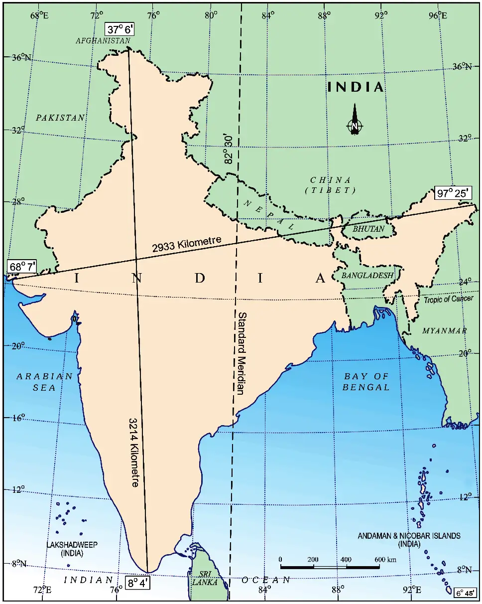
India has land mass area of 3.28 million square km and occupies 2.4 per cent of total geographical area of the world. It has a land boundary of about 15,200 km. The total coastline length of mainland India, including Andaman and Nicobar and Lakshadweep, is 7,516.6 km.
Location of India
- It is lying entirely in the Northern Hemisphere.
- The land extends between latitudes 8°4’N and 37°6’N and longitudes 68°7’E and 97°25’E.
- The Tropic of Cancer (23° 30’N) divides the country into almost two equal parts.
Features of India
- India is bounded by the young fold mountains in the northwest, north and northeast.
- It begins to taper around south of about 22° North latitude and extends towards the Indian Ocean, dividing it into two seas, the Arabian Sea on the West and the Bay of Bengal on its East.
- The latitudinal and longitudinal extent of the mainland is about 30°. Despite this fact, the east-west extent appears to be smaller than the north-south extent.
- There is a time lag of two hours from Gujarat to Arunachal Pradesh.
- The Standard Meridian of India (82°30’E) passes through Mirzapur (in Uttar Pradesh).
- The latitudinal extent influences the duration of day and night, as one move from South to North.
India and the World
- The Indian landmass has a central location between the East and the West Asia.
- India is a southward extension of the Asian continent.
- Strategic location of India: The trans Indian Ocean routes connects the countries of Europe in the West and the countries of East Asia.
- Close contact of India: The Deccan Peninsula protrudes into the Indian Ocean which helps India to establish close contact with West Asia, Africa and Europe from the western coast and with Southeast and East Asia from the eastern coast.
- Eminent position of India in Indian Ocean: No other country has a long coastline on the Indian Ocean like India. It also justifies the naming of an Ocean after it.
- India’s contacts with the world have continued through ages but her relationships through the land routes are much older than her maritime contacts.
- These routes have contributed to the exchange of ideas and commodities like the spices, muslin and other merchandise.
- The influence of Greek sculpture, and the architectural styles of dome and minarets from West Asia can be seen in different parts of India.
![Revision Notes Geography Class 9 Chapter 1 map]() India’s Neighbours
India’s Neighbours
 India’s Neighbours
- India occupies an important strategic position in South Asia. India shares its land boundaries with:
- Pakistan and Afghanistan in the Northwest.
- China (Tibet), Nepal and Bhutan in the North.
- Myanmar and Bangladesh in the East.
- Indian southern neighbours across the sea consist of the two island countries, namely Sri Lanka and Maldives.
- Sri Lanka is separated from India by a narrow channel of sea formed by the Palk Strait and the Gulf of Mannar.
- Maldives Islands are situated to the South of the Lakshadweep Islands.
Interesting points
- India is the seventh largest country of the world.
- As on 18 February 2021, India has 28 states and eight Union Territories.
- The opening of Suez Canal has reduced the distance of India from Europe by 7,000 km.
- Before 1947, there were two types of states in India:
- Provinces: These were ruled directly by British officials, who were appointed by the Viceroy.
- Princely states: These were ruled by local, hereditary rulers, who acknowledged sovereignty in return for local autonomy.
- The southernmost point of the Indian Union – ‘Indira Point’ got submerged under the sea water during the 2004 Tsunami.
- School Bhuvan: It is a portal providing map-based learning to bring awareness among the students about the country’s natural resources, environment, and their role in sustainable development.


