
Revision Notes of Geography for Class 9 Chapter 2 Physical Features of India
Revision Notes of Geography for Class 9 Chapter 2 Physical Features of India consists of India’s geographical features like vast stretches of plain land, hilly region, the rugged terrain with mountains and valleys, deserts, plateaus etc.
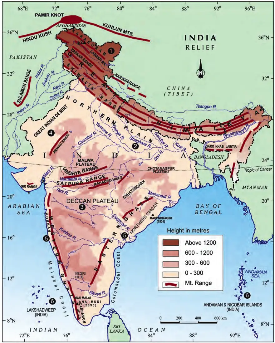
Physical Variations of India
- The Peninsular Plateau constitutes one of the ancient landmasses on the Earth’s surface. It is composed of igneous and metamorphic rocks with gently rising hills and wide valleys.
- The Himalayas and the Northern Plains are the most recent landforms.
- Youthful topography of Himalaya: It can be seen with high peaks, deep valleys and fast flowing rivers.
- Northern plains: These are formed of alluvial deposits.
Major Physiographic Divisions
- The Himalayan Mountains.
- The Northern Plains.
- The Peninsular Plateau.
- The Indian Desert.
- The Coastal Plains.
- The Islands.
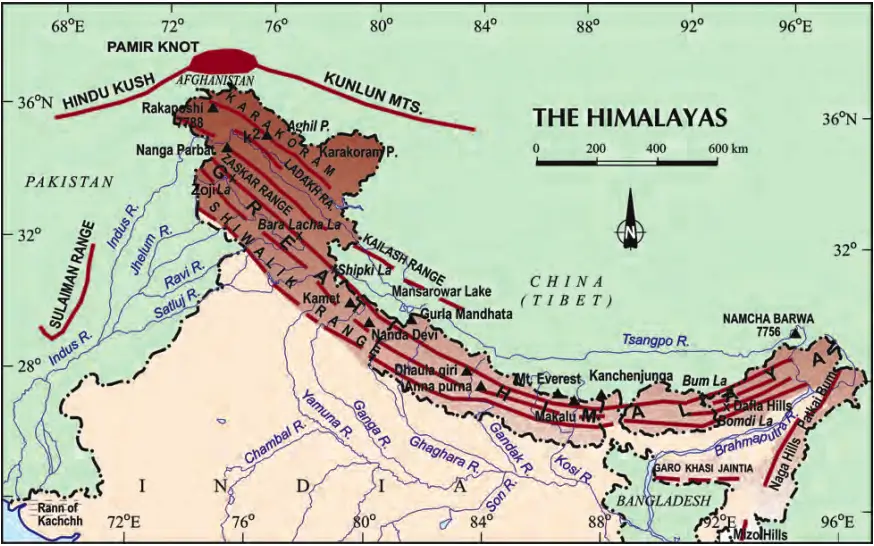
![Revision Notes Geography Class 9 Chapter 2 map 2]() The Himalayan Mountains
The Himalayan Mountains
 The Himalayan Mountains
- These are geologically young and structurally fold mountains which stretch over the Northern borders of India.
- These mountain ranges run in a West-East direction from the Indus to the Brahmaputra.
- They form an arc which covers about 2,400 Km.
- Their width varies from 400 Km in Kashmir to 150 Km in Arunachal Pradesh.
- Altitudinal variations are greater in the Eastern half than those in the Western half.
- These are the loftiest and one of the most rugged mountain barriers of the world.
Longitudinal division of Himalaya
The Himalaya consists of three parallel ranges in its longitudinal extent. Several valleys lie between these ranges.
![Revision Notes Geography Class 9 Chapter 2 map 1]() The Great or Inner Himalayas or the Himadri
The Great or Inner Himalayas or the Himadri
 The Great or Inner Himalayas or the Himadri
- This is Northern-most range.
- It is the most continuous range consisting of the loftiest peaks with an average height of 6,000 metres. It contains all prominent Himalayan peaks.
- The folds of the Great Himalayas are asymmetrical in nature.
- It is perennially snow bound and many glaciers descend from it.
- The core of this part of Himalayas is composed of granite.
Himachal or Lesser Himalaya
- The range lying to the South of the Himadri forms the most rugged mountain system of Himalaya.
- This range is mainly composed of highly compressed and altered rocks.
- The altitude varies between 3,700 and 4,500 metres and the average width is of 50 Km.
- Its most important and longest range is Pir Panjal range. Other prominent ones include – the Dhaula Dhar and the Mahabharat ranges.
- It consists of the famous valley of Kashmir, the Kangra and Kullu Valley in Himachal Pradesh. This region is well-known for its hill stations.
Outermost Range Shiwalik
- These extend over a width of 10-50 Km and its altitude vary between 900 and 1100 metres.
- These ranges are composed of unconsolidated sediments brought down by rivers from the main Himalayan ranges located in farther north.
- These valleys are covered with thick gravel and alluvium.
- The longitudinal valley lying between lesser Himalaya and the Shiwaliks are known as Duns. Dehra Dun, Kotli Dun and Patli Dun are some of the well-known Duns.
Division of Himalayas based on regions from West to East
These divisions have been demarcated by river valleys.
- Punjab Himalayas: It lies between Indus and Satluj. It is regionally known as Kashmir and Himachal Himalaya from west to east respectively.
- Kumaon Himalayas: It lies between Satluj and Kali rivers.
- Nepal Himalayas: It lies between the Kali and Teesta rivers.
- Assam Himalayas: It lies between Teesta and Dihang rivers. The Brahmaputra marks the Eastern-most boundary of the Himalayas.
- Purvanchal or the Eastern hills and mountains:
- The Himalayas bend sharply to the South and spread along the eastern boundary of India beyond the Dihang gorge.
- These hills mostly composed of strong sandstones, which are sedimentary rocks. They mostly run as parallel ranges and valleys and covered with dense forests.
- The Purvachal comprises the Patkai Hills, the Naga Hills, the Manipur Hills and the Mizo Hills.
The Northern Plain
- The Northern Plain has been formed by the interplay of the three major river systems, namely — the Indus, the Ganga and the Brahmaputra along with their tributaries.
- It is formed of alluvial soil which makes it fertile and is a densely populated physiographic division.
- It spreads over an area of 7 lakh sq. km.
- It is about 2400 km long and 240 to 320 km broad.
- It is an agriculturally productive area due to rich soil cover combined with adequate water supply and favourable climate.
- Various riverine islands are formed as the velocity of river decreases in the lower course due to gentle slope.
- The rivers form various distributaries in the lower course as they split into numerous channels due to the deposition of silt.
Divisions of the Northern Plain based on the Rivers:
Punjab Plains
- It is the western part of the Northern Plain and is dominated by the doabs.
- It is formed by the Indus and its tributaries and its larger part of this plain lies in Pakistan.
- The Indus and its tributaries — the Jhelum, the Chenab, the Ravi, the Beas and the Satluj originate in the Himalaya.
Ganga Plains
- It extends between Ghaggar and Teesta rivers.
- It spread over the states of North India, Haryana, Delhi, U.P., Bihar, etc.
Brahmaputra Plains
- Assam lies in the Brahmaputra plain.
- Brahmaputra and its tributaries cover vast areas of north east region. Its flow is highest in monsoon period which brings huge silt and fine soil particles in Assam and adjoining regions. It forms famous Riverine Island called Majuli Island.
Division of the Northern Plain based on Variations in Relief Features:
Bhabar
- It is formed by the deposition of pebbles by rivers in narrow belt of about 8 to 16 km in width lying parallel to the slopes of the Shiwaliks.
- All the streams disappear in this bhabar belt.
Terai
- It is a wet, swampy and marshy region formed South of the Bhabar region where the streams and rivers re-emerge.
- It is a thickly forested region full of wildlife. For example, Dudhwa National Park.
Bhangar
- It is the largest part of the northern plain and lies above the floodplains of the rivers and presents a terrace like feature.
- The soil in this region contains calcareous deposits, locally known as kankar.
Khadar
- It is the newer and younger deposits of the floodplains.
- They are renewed almost every year and are ideal for intensive agriculture.
The Peninsular Plateau
- It is tableland which is composed of the old crystalline, igneous and metamorphic rocks.
- It was formed due to the breaking and drifting of the Gondwana land.
- The plateau has broad and shallow valleys and rounded hills.
- One of its distinct features is the black soil area known as Deccan Trap which is of volcanic origin (Igneous Rocks).
- Aravali Hills lie on the western and north-western margins of the Peninsular Plateau.
- These are highly eroded hills and are found as broken hills.
- They extend from Gujarat to Delhi in a southwest-northeast direction.
- It has two broad divisions:
- The Central Highlands.
- The Deccan Plateau.
The Central Highlands
- The Central Highlands is the part that lies to the North of the Narmada River which covers a major area of the Malwa plateau.
- Vindhyan range:
- It is bounded by the Satpura range on the South and the Aravalis on the northwest.
- The further westward extension gradually merges with the sandy and rocky desert of Rajasthan.
- The rivers flowing in this region are the Chambal, the Sind, the Betwa and the Ken from southwest to northeast which indicates the slope.
- These are wider in the West but narrower in the East.
- Its eastward extensions are locally known as the Bundelkhand and Baghelkhand. The Chotanagpur plateau marks the further eastward extension, drained by the Damodar River.
The Deccan Plateau
- The Deccan Plateau is a triangular landmass that lies to the South of the river Narmada.
- The Satpura range flanks its broad base in the North, while the Mahadev, the Kaimur hills and the Maikal range forms its eastern extensions.
- It is higher in the West and slopes gently eastwards.
- Its extension is also visible in the northeast, locally known as the Meghalaya, Karbi-Anglong Plateau and North Cachar Hills.
- Malda Gap: It is a fault separating the Deccan Plateau and the Chota Nagpur.
- Three prominent hill ranges from the West to the East are the Garo, the Khasi and the Jaintia Hills.
- The western and Eastern Ghats makes its western and eastern edges, respectively.
- Western Ghats lie parallel to the western coast and can be crossed only through passes such as Thal, Bhor and Pal Ghats.
Western Ghats
- These are higher than the Eastern Ghats and its height progressively increases from North to South. Its average elevation is 900-1600 metres.
- They act as a barrier and responsible for orographic rain in the region.
- The highest peaks include the Anai Mudi (2,695 metres) and the Doda Betta (2,637 metres).
Eastern Ghats
- Its average elevation is 600 metres and stretch from the Mahanadi Valley to the Nigiris in the South.
- These are discontinuous and irregular and dissected by rivers draining into the Bay of Bengal.
- Its highest peak is Mahendragiri (1,501 metres) and the Shevroy Hills and the Javadi Hills are located to its southeast.
The Indian Desert
- The Indian Desert lies towards the western margins of the Aravali Hills.
- It is an undulating sandy plain covered with sand dunes and receives very low rainfall below 150 mm per year.
- It has arid climate and streams appear during the rainy season.
- Luni is the only large river in this region.
Coastal Plains
- The Peninsular plateau is flanked by stretch of narrow coastal strips, running along the Arabian Sea on the West and the Bay of Bengal on the East.
- Western Coast:
- It is a narrow plain sandwiched between the Western Ghats and the Arabian Sea.
- It consists of three sections:
- Konkan (Mumbai – Goa): It is the northern part of the coast.
- Kannad Plain: It is the central stretch.
- Malabar Coast: It is the southern stretch.
- Eastern Coast:
- Their plains are wide and level. Its northern part is referred to as the Northern Circar and the southern part is known as the Coromandel Coast.
- The Mahanadi, the Godavari, the Krishna and the Kaveri have formed extensive delta on this coast.
- Lake Chilika is an important feature along the eastern coast.
Islands
India has two groups of islands:
Lakshadweep Islands Group
- It lies close to the Malabar coast of Kerala and is composed of small coral islands.
- Earlier they were known as Laccadive, Minicoy and Amindive and these were named as Lakshadweep in 1973. It covers small area of 32 sq km.
- Kavaratti island is the administrative headquarters of Lakshadweep.
- It has great diversity of flora and fauna.
- The Pitti island, which is uninhabited, has a bird sanctuary.
Andaman and Nicobar Islands
- These are elongated chain of islands located in the Bay of Bengal extending from North to South. They are bigger in size and are more numerous and scattered.
- · These are divided into two broad categories – The Andaman in the North and the Nicobar in the South.
- It is believed that these islands are an elevated portion of submarine mountains.
- These islands have great diversity of flora and fauna and lie close to Equator and experience equatorial climate.
Interesting points
- ‘Doab’: It is made up of two words – ‘do’ meaning two and ‘ab’ meaning water. Similarly, ‘Punjab’, is also made up two words – ‘Punj’ meaning five and ‘ab’ meaning water.
- Majuli, in the Brahmaputra River, is the largest inhabited riverine island in the world.
- Chilika Lake: It is the largest salt-water lake in India and lies in the Odisha, to the south of the Mahanadi delta.
- India’s only active volcano is found on Barren Island in Andaman and Nicobar Islands.


