Geography : India Physical Environment
NCERT Solution Geography Class 11 Chapter 1 India – Location
In-Text Questions
Question (Page 5)
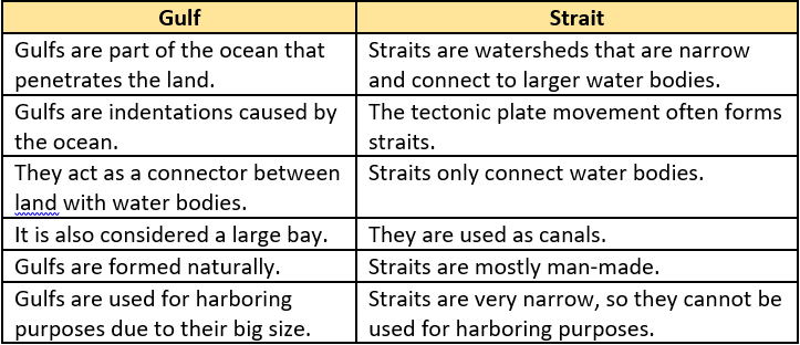
Question.1. Differentiate between a Gulf and a Strait.
NCERT Solution
Exercises
(Page 6)
Question.1. Choose the right answer from the four alternatives given below:
(i) Which one of the following latitudinal extent is relevant for the extent of lndia’s area?
(a) 8°41′ N – 35°7′ N
(b) 8°4′ N – 37°6′ N
(c) 8°4′ N – 35°6′ N
(d) 6°45′ N – 37°6′ N
Ans. (b) 8°4’N – 37°61 N
(ii) Which one of the following countries shares the longest land frontier with India?
(a) Bangladesh
(b) China
(c) Pakistan
(d) Myanmar
Ans. (a) Bangladesh
(iii) Which one of the following countries is larger in area than India?
(a) China
(b) Egypt
(c) France
(d) Iran
Ans. (a) China
(iv) Which one of the following longitudes is the standard meridian for India?
(a) 69°30′ E
(b) 82°30′ E
(c) 75°30′ E
(d) 90°30′ E
Ans. (b) 82°30′ E
Question.2. Answer the following questions in about 30 words.
(i) Does India need to have more than one standard time? If yes, why do you think so?
Ans. Yes, I think India needs to have more than one standard time. India has a large longitudinal expanse of about 30°. So even when the sun is still shining in western coast, it is already night in northeast. So we need two or three time zones to clearly reflect diurnal changes.
- There is time variation of 2 hours between Easternmost and the Westernmost parts of our country. The sun rises two hours earlier in Arunachal Pradesh as compared to Gujarat.
- This is because the earth is tilted and also it rotates in east to west direction. So while rotation, the Eastern parts of the world experiences the sun rays earlier as compared to the western parts of the world.
- Many countries like USA, Canada and Russia have more than one standard time because their longitudinal extent is large. India’s longitudinal extent is also 30° approximately.
Therefore, it is advisable to use more than one standard time.
(ii) What are the implications of India having a long coastline?
Ans. The total length of Coastline is 7,516.6 km.
- India is a southward extension of the Asian continent. The trans Indian Ocean routes which connect the countries of Europe in the west and the countries of East Asia provide a strategic central location to India.
- The Deccan Peninsular protrudes into the Indian Ocean, thus helping India to establish close contact with west Asia, Africa and Europe from the Wes tern coast and with Southeast Asia and East Asia from the Eastern coast.
- No other country has a long coastline on the Indian Ocean as India has and indeed, it is India’s eminent position in the Indian Ocean which justifies the naming of an Ocean after it.
It also has several advantages:
- It acts as a natural boundary
- More water area is available for marine trade
- Coastal patrolling is not tough as it is easy to demarcate boundary
- More availability of natural resources like oil rigs, petroleum, thorium etc.
- It acts as a strategic route for overseas trade
- More wind power can be generated nearby coastal areas.
- Enhanced scope for tourism
- Boosts the natural ecosystem and marine biodiversity
(iii) How is the latitudinal spread of India advantageous to her?
Ans. There are three major advantages of latitudinal extent-
- Tropic of cancer (23 \frac{1}{2}°.) – It divides India into 2 parts. Southern part is in the tropical zone while northern part is in the temperate zone. Therefore biodiversity in India is exceptional.
- It also brings climatic diversity in India which has many advantages.
- As we move from Kannyakumari to Jammu and Kashmir duration of day and night decreases by more than 4.5 hours.
- We have places of all climates. It makes India a subcontinent.
- It gives India varied climatic conditions, which has helped her to get different land forms, soils, minerals, forests, rivers and other natural vegetation.
- It has helped to take advantage of the Indian Ocean, the Arabian Sea and the Bay of Bengal for sea travel.
(iv) While the sun rises earlier in the east, say Nagaland and also sets earlier, how do the watches at Kohima and New Delhi show the same time?
Ans. The Indian Standard Meridian is 82°30’E and the time interval from Greenwich Mean Time is 5.30 hrs.While the sun rises earlier in the east, say Nagaland and also sets earlier but the watches at Kohima and New Delhi show the same time because India follows one standard time all over its land. Its the time shown at standard meridian of India. There is a general understanding among the countries of the world to select the Standard Meridian in multiples of 7° 30′ of longitude. Hence , 82°30′ E is chosen as the Standard Meridian of India and the time along the Standard Meridian of India passing through Mirzapur is taken as the Standard Time for the whole country. Both the cities Delhi and Kohima is in the east of 0° meridian. That is why they show the same difference of times.


